Yushu Xia

and 33 more

Rangelands provide significant environmental benefits through many ecosystem services, which may include soil organic carbon (SOC) sequestration. However, quantifying SOC stocks and monitoring carbon (C) fluxes in rangelands are challenging due to the considerable spatial and temporal variability tied to rangeland C dynamics, as well as limited data availability. We developed a Rangeland Carbon Tracking and Management (RCTM) system to track long-term changes in SOC and ecosystem C fluxes by leveraging remote sensing inputs and environmental variable datasets with algorithms representing terrestrial C-cycle processes. Bayesian calibration was conducted using quality-controlled C flux datasets obtained from 61 Ameriflux and NEON flux tower sites from Western and Midwestern U.S. rangelands, to parameterize the model according to dominant vegetation classes (perennial and/or annual grass, grass-shrub mixture, and grass-tree mixture). The resulting RCTM system produced higher model accuracy for estimating annual cumulative gross primary productivity (GPP) (R2 > 0.6, RMSE < 390 g C m-2) than net ecosystem exchange of CO2 (NEE) (R2 > 0.4, RMSE < 180 g C m-2), and captured the spatial variability of surface SOC stocks with R2 = 0.6 when validated against SOC measurements across 13 NEON sites. Our RCTM simulations indicated slightly enhanced SOC stocks during the past decade, which is mainly driven by an increase in precipitation. Regression analysis identified slope, soil texture, and climate factors as the main controls on model-predicted C sequestration rate. Future efforts to refine the RCTM system will benefit from long-term network-based monitoring of rangeland vegetation biomass, C fluxes, and SOC stocks.

Bianca Adler

and 16 more

The structure and evolution of the atmospheric boundary layer (ABL) under clear-sky fair weather conditions over mountainous terrain is dominated by the diurnal cycle of the surface energy balance and thus strongly depends on surface snow cover. We use data from three passive ground-based infrared spectrometers deployed in the East River Valley in Colorado’s Rocky Mountains to investigate the response of the thermal ABL structure to changes in surface energy balance during the seasonal transition from snow-free to snow-covered ground. Temperature profiles were retrieved from the infrared radiances using the optimal estimation physical retrieval TROPoe. A nocturnal surface inversion formed in the valley during clear-sky days, which was subsequently mixed out during daytime with the development of a convective boundary layer during snow-free periods. When the ground was snow covered, a very shallow convective boundary layer formed, above which the inversion persisted through the daytime hours. We compare these observations to NOAA’s operational High-Resolution-Rapid-Refresh (HRRR) model and find large warm biases on clear-sky days resulting from the model’s inability to form strong nocturnal inversions and to maintain the stable stratification in the valley during daytime when there was snow on the ground. A possible explanation for these model shortcomings is the influence of the model’s relatively coarse horizontal grid spacing (3 km) and its impact on the model’s ability to represent well-developed thermally driven flows, specifically nighttime drainage flows.

Kashif Mahmud

and 8 more

Drylands occupy ~40% of the land surface and are thought to dominate global carbon (C) cycle inter-annual variability (IAV). Therefore, it is imperative that global terrestrial biosphere models (TBMs), which form the land component of IPCC earth system models, are able to accurately simulate dryland vegetation and biogeochemical processes. However, compared to more mesic ecosystems, TBMs have not been widely tested or optimized using in situ dryland CO2 fluxes. Here, we address this gap using a Bayesian data assimilation system and 89 site-years of daily net ecosystem exchange (NEE) data from 12 southwest US Ameriflux sites to optimize the C cycle parameters of the ORCHIDEE TBM. The sites span high elevation forest ecosystems, which are a mean sink of C, and low elevation shrub and grass ecosystems that are either a mean C sink or “pivot” between an annual C sink and source. We find that using the default (prior) model parameters drastically underestimates both the mean annual NEE at the forested mean C sink sites and the NEE IAV across all sites. Our analysis demonstrated that optimizing phenology parameters are particularly useful in improving the model’s ability to capture both the magnitude and sign of the NEE IAV. At the forest sites, optimizing C allocation, respiration, and biomass and soil C turnover parameters reduces the underestimate in simulated mean annual NEE. Our study demonstrates that all TBMs need to be calibrated for dryland ecosystems before they are used to determine dryland contributions to global C cycle variability and long-term carbon-climate feedbacks.

Brian J. Butterworth

and 44 more

The Chequamegon Heterogeneous Ecosystem Energy-balance Study Enabled by a High-density Extensive Array of Detectors 2019 (CHEESEHEAD19) is an ongoing National Science Foundation project based on an intensive field campaign that occurred from June-October 2019. The purpose of the study is to examine how the atmospheric boundary layer responds to spatial heterogeneity in surface energy fluxes. One of the main objectives is to test whether lack of energy balance closure measured by eddy covariance (EC) towers is related to mesoscale atmospheric processes. Finally, the project evaluates data-driven methods for scaling surface energy fluxes, with the aim to improve model-data comparison and integration. To address these questions, an extensive suite of ground, tower, profiling, and airborne instrumentation was deployed over a 10×10 km domain of a heterogeneous forest ecosystem in the Chequamegon-Nicolet National Forest in northern Wisconsin USA, centered on the existing Park Falls 447-m tower that anchors an Ameriflux/NOAA supersite (US-PFa / WLEF). The project deployed one of the world’s highest-density networks of above-canopy EC measurements of surface energy fluxes. This tower EC network was coupled with spatial measurements of EC fluxes from aircraft, maps of leaf and canopy properties derived from airborne spectroscopy, ground-based measurements of plant productivity, phenology, and physiology, and atmospheric profiles of wind, water vapor, and temperature using radar, sodar, lidar, microwave radiometers, infrared interferometers, and radiosondes. These observations are being used with large eddy simulation and scaling experiments to better understand sub-mesoscale processes and improve formulations of sub-grid scale processes in numerical weather and climate models.

Timothy Wilson

and 7 more

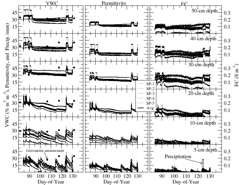
The U.S. Climate Reference Network (USCRN) has been engaged in ground-based soil water and soil temperature measurements since 2009. As a nationwide climate network, the network stations are distributed across vast complex terrains. Due to the expansive distribution of the network and the related variability in soil properties, obtaining site-specific calibrations for sensors is a significant and costly endeavor. Presented here are three commercial-grade electromagnetic sensors, with built-in thermistors to measure both soil water and soil temperature, including the SoilVUE10 Time Domain Reflectometry (TDR) probe (hereafter called SP, for SoilVUE Probe) (Campbell Scientific, Inc., Logan, UT), the 50 MHz coaxial impedance dielectric sensor (model HydraProbe (hereafter called HP), Stevens Water Monitoring Systems, Inc., Portland, OR), and the TDR-315L Acclima Probe (hereafter called AP) sensor (model TDR-315L, Acclima, Inc., Meridian, ID), which were evaluated in a nonconductive loam soil in Oak Ridge, Tennessee, USA from 2021 to 2022. The manufacturer-supplied calibration equation for loam soils was successfully used in this study. Measurements of volumetric water content by SP were much lower than gravimetric measurements in the top 20-cm soil horizon, where soil water showed relatively large spatial variability. Study results highlight that the SP may be an important alternative to reduce soil disturbances that usually ensue when HP and AP sensors are installed; however, in-situ calibrations are essential for the SP for xeric soil water conditions.