Zahra Faghih

and 9 more

Although marine controlled source electromagnetic (CSEM) methods are effective for investigating offshore freshened groundwater (OFG) systems, interpreting the spatial extent and salinity of OFG remains challenging. Integrating CSEM resistivity models with information on sub-surface properties, such as host-rock porosity, allows for estimates of pore-water salinity. However, deterministic inversion approaches pose challenges in quantitatively analyzing these estimates as they provide only one best-fit model with no associated estimate of model parameter uncertainty. To address this limitation, we employ a trans-dimensional Markov-Chain Monte-Carlo inversion on marine CSEM data, under the assumption of horizontal stratification, collected from the Canterbury Bight, New Zealand. We integrate the resulting posterior distributions of electrical resistivity with borehole and seismic reflection data to quantify pore-water salinity with uncertainty estimates. The results reveal a low-salinity groundwater body in the center of the survey area at varying depths, hosted by consecutive silty- and fine-sand layers approximately 20 to 60 km from the coast. These observations support the previous study’s results obtained through deterministic 2-D inversion and suggest freshening of the OFG body closer to the shore within a permeable, coarse-sand layer 40 to 150 m beneath the seafloor. This implies a potential active connection between the OFG body and the terrestrial groundwater system. We demonstrate how the Bayesian approach constrains the uncertainties in resistivity models and subsequently in pore-water salinity estimates. Our findings highlight the potential of Bayesian inversions in enhancing our understanding of OFG systems, providing crucial boundary conditions for hydrogeological modeling and sustainable water resource development.
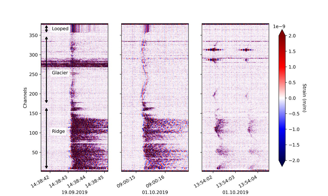
We demonstrate the logistic feasibility and scientific potential of Distributed Acoustic Sensing (DAS) in alpine volcano-glacial environments that are subject to a broad range of natural hazards. Our work considers the Mount Meager massif, an active volcanic complex in British Columbia, estimated to have the largest geothermal potential in Canada, and home of Canada’s largest recorded landslide in 2010. From September to October 2019, we acquired continuous strain data, using a 3 km long fiber-optic cable, deployed on a ridge of Mount Meager and on the uppermost part of a glacier above 2000 m altitude. The data analysis detected a broad range of unexpectedly intense, low-magnitude, local seismicity. The most prominent events include long-lasting, intermediate-frequency (0.01 - 1 Hz) tremor, and high-frequency (5 - 45 Hz) earthquakes that form distinct spatial clusters and often repeat with nearly identical waveforms. We conservatively estimate that the number of detectable high-frequency events varied between several tens and nearly 400 per day. We also develop a beamforming algorithm that uses the signal-to-noise ratio (SNR) of individual channels, and implicitly takes the direction-dependent sensitivity of DAS into account. Both the tremor and the high-frequency earthquakes are most likely related to fluid movement within Mount Meager’s geothermal reservoir. Our work illustrates that DAS carries the potential to reveal previously undiscovered seismicity in challenging environments, where comparably dense arrays of conventional seismometers are difficult to install. We hope that the logistics and deployment details provided here may serve as a starting point for future DAS experiments.

Joshua Purba

and 2 more

To improve our understanding of the Canoe Reach Geothermal Field in the Rocky Mountain Trench of western Canada, we examine the distribution of local earthquakes using a network of 10 broadband seismometers deployed over a 40 by 60 km area across the trench. The Canoe Reach area exhibits strong cultural noise from communities, roads and trains that makes detecting earthquake signals challenging. We propose detecting earthquakes in the area of the trench by measuring the kurtosis of the seismic signal, which is a statistical moment representing the distribution tail and is insensitive to emerging signals but more sensitive to impulsive earthquake onsets. Examining the kurtosis of the three-component seismograms for four months of data, we identified eight local earthquakes. An earthquake catalog produced by STA/LTA detections found 11 events for the same four-month period, four of which were detected through our kurtosis approach. By further exploring the kurtosis detections, we are refining our catalog to identify the source of discrepancies between it and the STA/LTA catalog. We then estimated locations of our detected events, and the uncertainties of those locations, through nonlinear Bayesian sampling. This method treats the origin times, half-space velocities, and the picking noise for P and S arrivals as unknowns. We employed this parameterization to test whether Bayesian sampling could account for the challenging noise environment. Locating our detected events found that five events occurred outside the seismic network and three events occurred inside. The average horizontal and vertical uncertainty is 28 and 19 km respectively for the outside events. These uncertainties are lower at 7 and 9 km for the inside events. While the inside events exhibit lower spatial uncertainties than the outside events, their uncertainties remain large. We then examined whether the uncertainties could be further improved by jointly locating multiple events. Jointly inverting two of the events from within the array decreased their average horizontal uncertainty from 6.5 to 2.5 km and the vertical from 14 to 7 km. Reducing uncertainties in the locations of the events in this manner will clarify their distribution and all for an improved understanding of the seismicity and structure of the Rocky Mountain Trench.