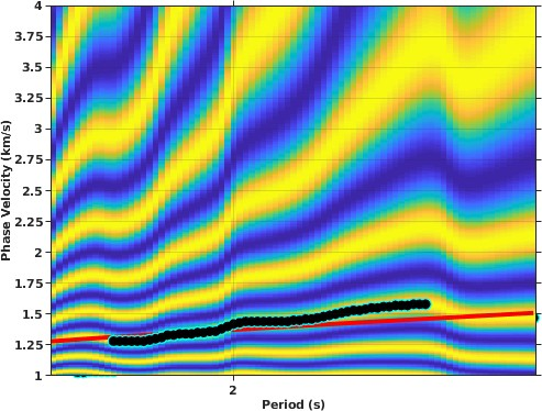
We construct a new shear velocity model for the San Gabriel, Chino and San Bernardino basins located in the northern Los Angeles area using ambient noise correlation between dense linear nodal arrays, broadband stations, and accelerometers. We observe Rayleigh wave and Love wave in the correlation of vertical (Z) and transverse (T) components, respectively. By combining Hilbert and Wavelet transforms, we obtain the separated fundamental and first higher mode of the Rayleigh wave dispersion curves based on their distinct particle motion polarization. Receiver functions, gravity, and borehole data are incorporated into the prior model to constrain the basin depth. Our 3D shear wave velocity model covers the upper 3 to 5 km of the basin structure in the San Gabriel and San Bernardino basin area. The Vs model is in agreement with the geological and geophysical cross-sections from other studies, but discrepancies exist between our model and a Southern California Earthquake Center (SCEC) community velocity model. Our shear wave velocity model shows good consistency with the CVMS 4.26 in the San Gabriel basin, but predicts a deeper and slower sedimentary basin in the San Bernardino and Chino basins than the community model.