Simone Pilia

and 5 more

The Semail ophiolite, a thick thrust sheet of Late Cretaceous oceanic crust and upper mantle, was obducted onto the previously rifted Arabian continental margin in the Late Cretaceous, and now forms part of the United Arab Emirates (UAE)-Oman mountain belt. A deep foreland basin along the west and SW margin of the mountains developed during the obduction process, as a result of flexure due to loading of the ophiolite and underlying thrust sheets. The nature of the crust beneath the deep sedimentary basins that flank the mountain belt, and the extent to which the Arabian continental crust has thickened due to the obduction process are outstanding questions. We use a combination of active- and passive-source seismic data to constrain the stratigraphy, velocity structure and crustal thickness beneath the UAE-Oman mountains and its bounding basins. Depth-migrated multichannel seismic-reflection profile data are integrated in the modelling of traveltimes from long offset reflections and refractions, which are used to resolve the crustal thickness and velocity structure along two E-W onshore/offshore transects in the UAE. Additionally, we apply the virtual deep seismic sounding method to distant earthquake data recorded along the two transects to image crustal thickness variations. Active seismic methods define the Semail ophiolite as a high-velocity body dipping to the east at 40-45˚. The new crustal thickness model presented in this work provides evidence that a crustal root is present beneath the Semail ophiolite, suggesting that folding and thrusting during the obduction process may have thickened the crust by 16 km.

Deborah Wehner

and 7 more

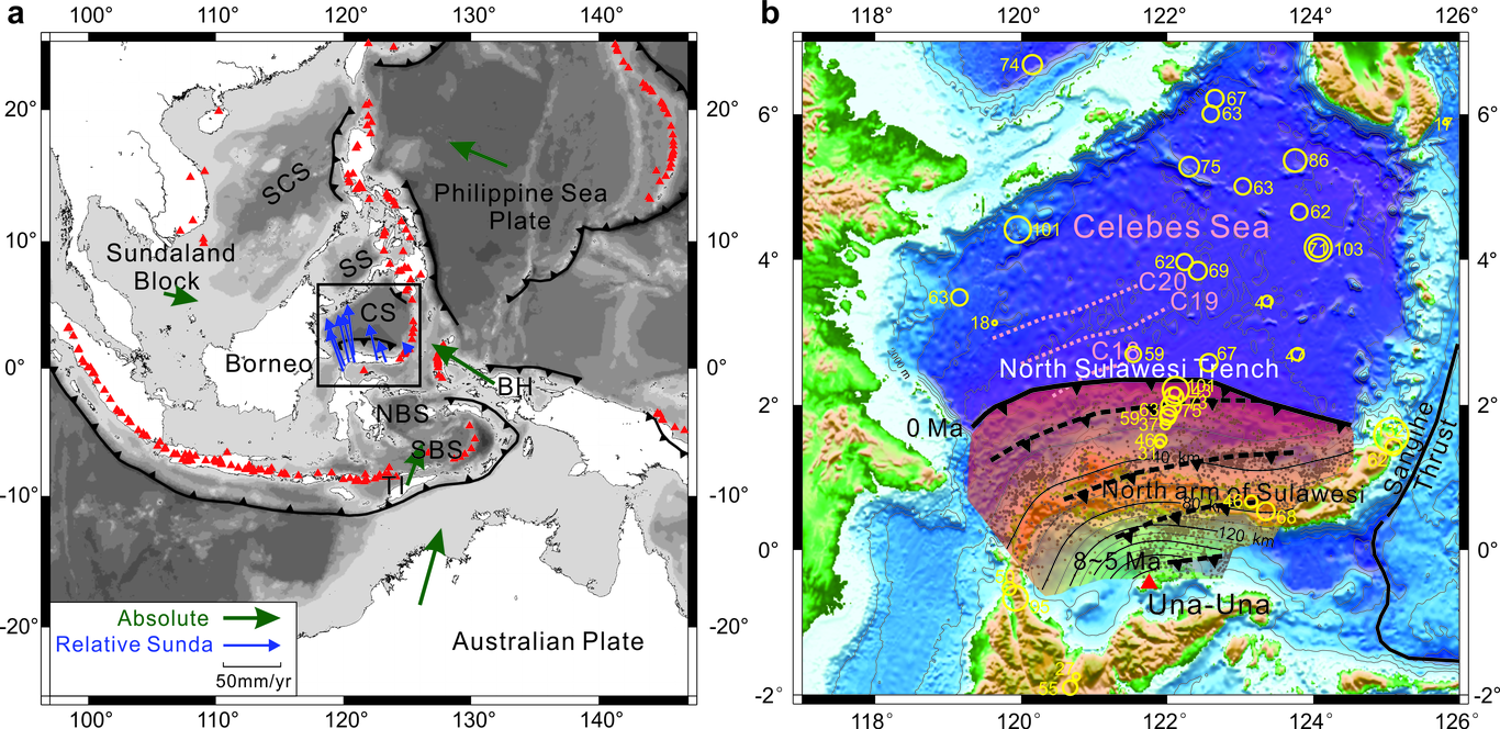
We present a new 3-D seismic structural model of the eastern Indonesian region and its surroundings from full-waveform inversion (FWI) that exploits seismic data filtered at periods between 15 - 150 s. SASSY21 - a recent 3-D FWI tomographic model of Southeast Asia - is used as a starting model, and our study region is characterized by particularly good data coverage, which facilitates a more refined image. We use the spectral-element solver Salvus to determine the full 3-D wavefield, accounting for the fluid ocean explicitly by solving a coupled system of acoustic and elastic wave equations. This is computationally more expensive but allows seismic waves within the water layer to be simulated, which becomes important for periods ≤ 20 s. We investigate path-dependent effects of surface elevation (topography and bathymetry) and the fluid ocean on synthetic waveforms, and compare our final model to the tomographic result obtained with the frequently used ocean loading approximation. Furthermore, we highlight some of the key features of our final model - SASSIER22 - after 34 L-BFGS iterations, which reveals detailed anomalies down to the mantle transition zone, including a convergent double-subduction zone along the southern segment of the Philippine Trench, which was not evident in the starting model. A more detailed illumination of the slab beneath the North Sulawesi Trench reveals a pronounced positive wavespeed anomaly down to 200 km depth, consistent with the maximum depth of seismicity, and a more diffuse but aseismic positive wavespeed anomaly that continues to the 410 km discontinuity.