Giulio Castelli

and 7 more

Water resources management is fundamental for rural communities in drylands. Water Harvesting Technologies (WHT) intercept and store the excess rainfall (surface runoff) in soils for increased plant available water and agricultural productivity. The so-called ‘Marab’ WHT was initially developed by Middle Eastern agro-pastoralists that reside or commute in semi-arid and arid rangelands. The Marab WHT is a macro-catchment measure consisting of earth dams and stone spillways along the contours of a lowland depression or floodplain. Dependent on the local context (i.e. climate, soil, management, etc.) the established Marabs show highly-variable effectiveness. This study aims at filling the knowledge gap on the WHT’s performance in changing environments by simulating its hydro-agrological effects for different soils and climatic conditions using the AquaCrop model. A case study performed for a Jordanian Marab over three seasons (2019-2022) confirms its huge improvement potential for barley production. Through Marab-farming, barley production reached 8.37 t ha -1 on average, versus highly variable 0.34 t ha -1 without the WHT. The simulation-based assessment of soil textures identified that silty soils have the largest potential for producing up to 9.25 t ha -1 barley, compared to 6.60 t ha -1 produced in clay soils. Assessing different climate scenarios, a slight increase in daily average temperatures (+ 0.5°C) led to a considerable production decline of 4-8%, while a significant reduction of precipitation (-20%) decreased biomass production by a similar rate (4-10%). This underlines the robustness of the ‘Marab’ WHT to rainfall amount variation. However, simulations also highlight the sensitivity of timing and frequency of flood events: removing the last and the first flood event reduced biomass production by approximately 50% and 80% respectively, while the barley fails to develop if both events were suppressed.

Giulio Castelli

and 8 more

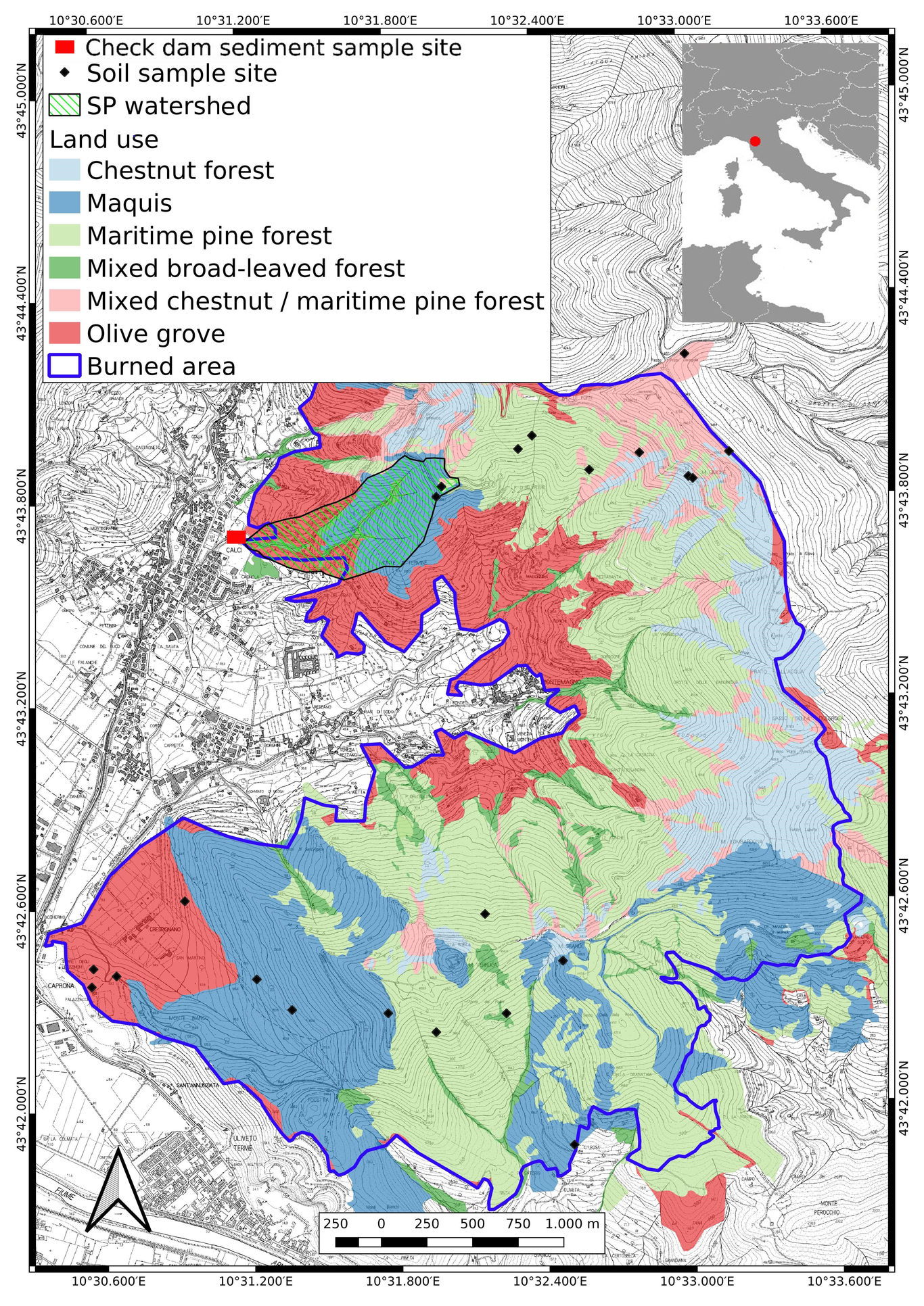
Wildfires are an increasingly alarming phenomenon that affects forests and agro-ecosystems, generating several cascade effects among which soil erosion is one of the most deleterious. A robust body of data-based evidence on post-fire soil erosion and sediment yield at watershed scale is thus required, especially dealing with areas where wildfires are particularly frequent, such as the Mediterranean Basin. This study analyses the impact of the first rains after a large wildfire in terms of soil erosion and sediment yield at watershed scale in a Mediterranean area, the Pisan Mountains, Central Italy. Here about 1,000 ha of olive groves, maquis, maritime pine and chestnut forests burned. Fire severity was mapped by remote sensing and checked by a field survey. Sediment yield was assessed by sampling the earthy material deposited upstream a check dam at the outlet of the watershed. Finally, a hydrological model was developed in HEC-HMS environment for exploring the relationship between the erosion-deposition events observed in the watershed and the rainfall-induced hydrological processes. The first two post-fire rainy events relocated a high amount of sediments, mostly non-organic, perhaps already in the stream before the fire, while the subsequent four rains deposited materials rich in pyrogenic organic matter. Overall, the soil erosion caused by such six main post-fire rains – the larger of which had a return time of one year – was estimated to amount to 7.85 t ha -1, corresponding to 42% of the watershed average annual potential erosion rate in normal conditions. This value is lower than expected and, overall, moderate if compared to other Mediterranean case studies, possibly because of the nature of soils in the studied watershed, i.e. shallow and quite stony, thus poor in fines prone to erosion.

Luigi Piemontese

and 4 more

Sand dams are simple and effective structures built across ephemeral riverbeds in arid/semi-arid regions to harvest water within sand pores and increase water availability and quality for rural communities. The complex morphological, hydrological, social and economic conditions that make sand dams a beneficial tool for water resilience are largely influenced by the siting phase. Proper location of a sand dam can reduce community’s travel time to water points, reduce water conflicts and increase food security through expansion of irrigated agriculture. On the other hand, a misplacement of sand dams can, at worst, increase disparities in water access and increase local conflicts. To approach a viable siting of sand dams, most projects are developed and delivered with the community through a bottom-up approach. However, in case of large-scale project, remote sensing and biophysical analysis are the dominant approach, leaving the socio-economic component at the margins of the siting strategy and eventually affecting the benefits to local communities. In this paper, we propose a large-scale participatory methodology to sand dams siting, which draws on mixed-methods connecting the conventional top-down biophysical analysis with bottom-up participatory research. We first describe the generic approach developed for sand dams siting in Namibe, a semi-arid region of South-west of Angola, then we draw on our case to propose a generic approach to large-scale participatory siting beyond Namibe.