Yunxiang Chen

and 10 more

Quantifying the multiscale feedback between hydrodynamics and biogeochemistry is key to reliable modeling of river corridor systems. However, accurate and efficient hydrodynamics models over large spatiotemporal scales have not yet been established due to limited surveys of riverbed roughness and high computational costs. This work presents a semi-automated workflow that combines topographic and water stage surveys, computational fluid dynamics modeling, distributed wall resistance modeling, and high-performance computing to simulate flow in a 30-kilometer-long reach at the Columbia River during 2011-2019. The results show that this workflow enables a high accuracy in modeling water stage at all seven survey locations during calibration (1 month) and validation (65 months) periods. It also enables a high computational efficiency to model the streamflow during a 58-month solution-time within less than a 6-day wall-clock-time with mesh number, time step, and CPU hours of about 1.2 million, 3 seconds, and 1.1 million hours, respectively. Using the well-validated results, we show that riverbed dynamic pressure is randomly distributed over all spatiotemporal scales with its cross-sectional average values approximately quantified by a normal distribution with a mean and standard deviation of -0.353 m and 0.0352 m; bed shear stress is affected by flowrate and large- and small-scale topographic features with cross-sectional maximum values following a smooth but asymmetric distribution with 90% of its value falling between 5 Pa and 35 Pa; and hydrostatic pressure is influenced by flowrate and large-scale topographic features with cross-sectional maximum values quantified by a discontinuous and skewed distribution determined by streamwise topographic variations.

Pin Shuai

and 9 more

Hydrologic exchange flows (HEFs) across the river-aquifer interface have important implications for biogeochemical processes and contaminant plume migration in the river corridor, yet little is known about the hydrogeomorphic factors that control HEFs dynamics under dynamic flow conditions. Here, we developed a 3-D numerical model for a large regulated river corridor along the Columbia River to study how HEFs are controlled by the interplays between dam-regulated flow conditions and hydrogeomorphic features of such river corridor system. Our results revealed highly variable intra-annual spatiotemporal patterns in HEFs along the 75-km river reach, as well as strong interannual variability with larger exchange volumes in wet years than dry years. In general, the river was losing during late spring to early summer when the river stage was high, and river was gaining in fall and winter when river stage was low. The magnitude and timing of river stage fluctuations controlled the timing of high exchange rates. Both river channel geomorphology and the thickness of a highly permeable river bank geologic layer controlled the locations of exchange hot spots, while the latter played a dominant role. Dam-induced, sub-daily to daily river stage fluctuations drove high-frequency variations in HEFs across the river-aquifer interfaces, resulting in greater overall exchange volumes as compared to the case without high-frequency flows. Our results demonstrated that upstream dam operations enhanced the exchange between river water and groundwater with strong potential influence on the associated biogeochemical processes and on the fate and transport of groundwater contaminant plumes in such river corridors.

Timothy Scheibe

and 18 more

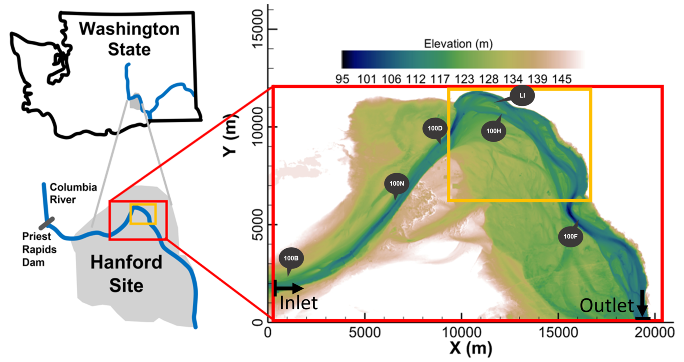
River corridors, the spatial domains around rivers in which river water interacts with surrounding sediment and rock, are important components of watersheds. They comprise extremely complex ecosystems: heterogeneous at all spatial scales with strong temporal dynamics, coupled biological, geochemical, and hydrologic processes, and ubiquitous human impacts. We present several ways that our project, focused around the 75 km Hanford Reach of the Columbia River but with multiple connections to other systems, is addressing this challenge. These include 1) deployment of intensive, automated sensor networks supplemented by data from the Hanford Environmental Information System (HEIS) for hyporheic zone monitoring 2) data assimilation of these and other data into models using joint hydrologic and geophysical inversion, 3) integrating MASS2 model outputs and bathymetry data using machine learning to classify hydromorphologic features, 4) a community-based effort to develop broad understanding of organic carbon biogeochemistry and microbiomes in diverse river systems, and 5) use of multi-‘omics data to develop new biogeochemical reaction networks. These underpin the incorporation of process understanding and diverse data into high-resolution mechanistic models, and employment of those models to develop reduced-order models that can be applied at large scales while retaining the effects of local features and processes. In so doing we are contributing to reduction of uncertainties associated with major Earth system biogeochemical fluxes, thus improving predictions of environmental and human impacts on water quality and riverine ecosystems and supporting environmentally responsible management of linked energy-water systems.