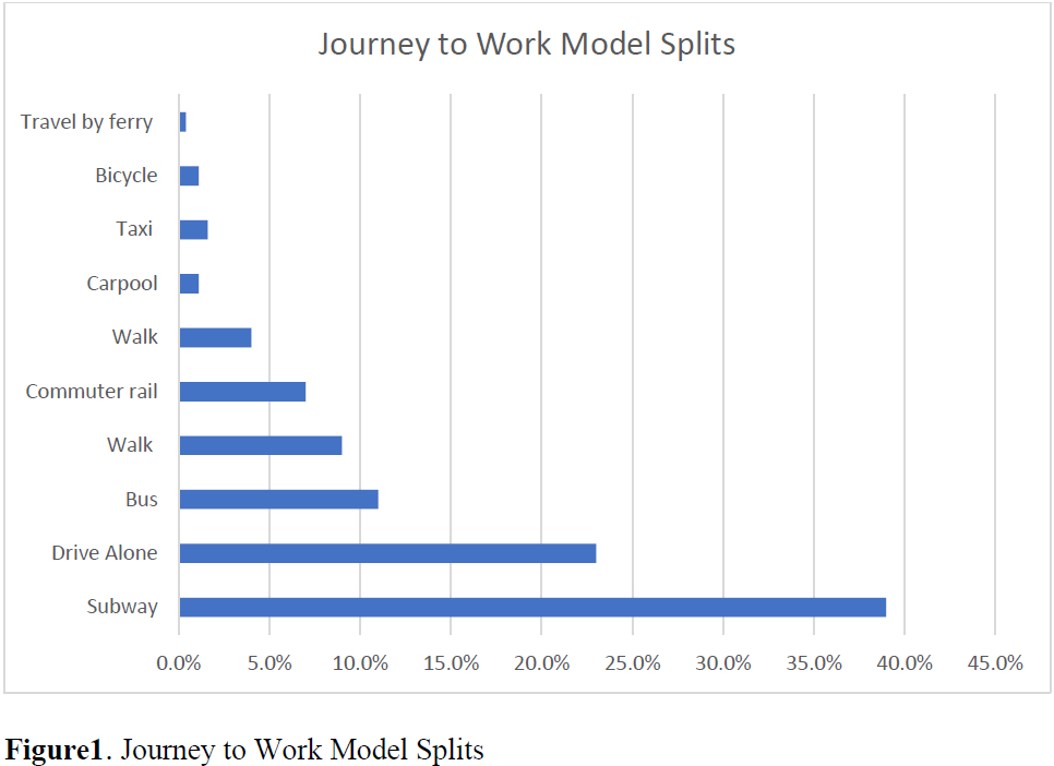
Abstract:This paper's main objective is to develop and validate a framework prediction based on the use of various classifiers that operate on merged attributes to obtain more effective crash predictions from classifiers' outcomes. In order to systematically classify the crash through feature selection techniques, a data-driven approach was adopted to investigate the best potential classifier to predict the contributing factors and the number of injuries/fatalities per collision. To produce diversity in learning techniques, by using the following methods Bayes Network, Naïve Bayes, J48, and K-Nearest Neighbor (KNN) for the year of 2019 and the 100 intersections with the high-risk for collisions generated from the NYPD Collision data using the 2014-2019 dataset. The findings indicate the classifier's accuracy was highest for the Naïve Bayes with 81.59%, followed by the Bayes Network with an accuracy of 81.57%, and J48 resulted in an accuracy of 80.81%, and KNN performed the lowest accuracy of 80.20%. Overall, the methodology and outcomes offer new insights into crash detection and be a useful method to improve intervention efforts relevant to safer transportation planning. The geospatial analysis was performed, providing insight into areas with a frequency of different types of collisions that could establish a pattern based on reoccurring locations within the same area/zip code. The geospatial analysis indicates that boroughs of Brooklyn and Queens have the highest numbers of collisions. The research also analyzed the relationship between the number of collisions and the conditions of the pavement. The findings suggest that the condition of the pavement has an impact on the number of crashes. The total number of accidents was 55,827 and 3,622 intersecting with a poorly graded condition of pavement; 227 total fatalities and 127 intersecting with a poorly rated condition of the pavement. Keywords:Bayes Network, Naïve Bayes, J48, KNN and Geospatial Analysis, High-Risk Intersections, and Crash prediction.Introduction At over 27,000 persons per square mile, New York has the highest population density of any major city in the United States [27]. In developing safer roadways, planners and engineers must understand that the city is very diverse in transportation modes. The risk defines a probability of multiple levels of damages from a transportation planning procedure, such as injury, fatalities, liability, and property damages; all these elements create roadway vulnerabilities. As part of the roadway safety plan, the probability of an outcome, and any potential severity of the outcome if it occurs. Collision prediction is a critical component of transportation planning; it plays a role in the decision-making process and funding allocation to certain areas. (FHWA Manual, 2010) About 1.4 million households own a car compared to 3.1 total households based on the census tract. According to New York City Economic Development Corporation's (NYCEDC) study from 2018, the information is derived from Metro System Ridership and 2011-2015 ACS Microdata; the following are the average percentage of the vehicle ownership borough base: Manhattan, 22 percent, Brooklyn 44 percent, Queens 62 percent, Bronx 40 percent, and Staten Island 83 percent. With diverse vehicle types and roadway characteristics, 27 percent of commuters' travel via truck, car, or van. (NYCEDC, 2018) As a safety plan, NYC has adopted Vision Zero to achieve zero fatality. Based on the 2014 Vision Zero Year 4 Report, over 250 people were killed, and 4,000 were seriously injured in traffic crashes. Compared to the June 2020 Vision Zero report, there was a decrease in the number of fatalities to a total of 220 [4].