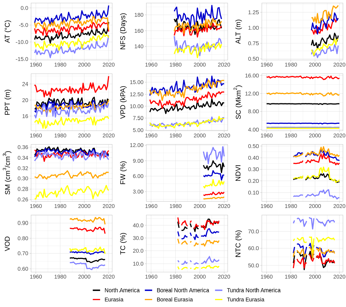
AUTHOREA
Log in Sign Up Browse Preprints
LOG IN SIGN UP

1116 environmental sciences Preprints

Related keywords
environmental sciences covid-19 transpiration crop and pasture production soil sciences and food sciences atmospheric chemistry Applied computing soil biochemistry hydrology stable isotopes public health geography marine and estuarine ecology (incl. marine ichthyology) marine geology (oceanography) environmental biogeochemistry atmospheric sciences education chemical oceanography climatology (global change) geophysics veterinary climate change impacts and adaptation human society and farm management + show more keywords
quality of water environmental management geochemistry oceanography ecological physiology paleontology geography of natural resources geomorphology ecology agricultural limnology agriculture organic geochemistry pollution and contamination meteorology terrestrial ecology geology low temperature geochemistry biological sciences land health sciences information and computing sciences machine learning
FOLLOW
  • Email alerts
  • RSS feed
Please note: These are preprints and have not been peer reviewed. Data may be preliminary.
Development of 2D Unstructured Meshes Using a Sizing Function Derived from Euclidean...
Henok Kefelegn
Henok Kefelegn

Henok Kefelegn

and 9 more

July 04, 2022
Generation of 2D meshes with reduced number of elements while yielding accurate results is a major challenge in coastal numerical models. High-quality 2D unstructured meshes were generated using sizing functions, which were computed from Euclidean distances to coastal features at given spatial locations and assigned element sizes based on calculated distances. The coastal features consist of National Water Model (NWM) streamlines, National Hydrography Dataset (NHD), NOAA Medium Resolution Shoreline and bathymetric features from the United States Army Corps of Engineers (USACE). This approach allows improved integration of the hydrodynamic D-Flow Flexible Mesh (D-Flow FM) model into the hydrological NWM and results in an optimum number of computational points. The method grants the user flexibility to control element sizes and avoids manual iterative procedures by determining an optimal element-sizing function that defines small element scales in regions where geometrical and physical characteristics exist, with larger scales elsewhere. Newly created continental-scale meshes on the Atlantic Ocean, Gulf of Mexico and Pacific Ocean coastlines demonstrate the application of the proposed method for automatic generation of unstructured, high-quality 2D meshes.
A New Aerosol Dry Deposition Model for Air Quality and Climate Modeling
Jonathan E. Pleim
Limei Ran

Jonathan E. Pleim

and 4 more

July 25, 2022
Dry deposition of aerosols from the atmosphere is an important but poorly understood and inadequately modeled process in atmospheric systems for climate and air quality. Comparisons of currently used aerosol dry deposition models to a compendia of published field measurement studies in various landscapes show very poor agreement over a wide range of particle sizes. In this study, we develop and test a new aerosol dry deposition model that is a modification of the current model in the Community Multiscale Air Quality (CMAQ) model. The new model agrees much better with measured dry deposition velocities across particle sizes. The key innovation is the addition of a second inertial impaction term for microscale obstacles such as leaf hairs, microscale ridges, and needleleaf edge effects. The most significant effect of the new model is to increase the mass dry deposition of the accumulation mode aerosols in CMAQ. Accumulation mode mass dry deposition velocities increase by almost an order of magnitude in forested areas with lesser increases for shorter vegetation. Peak PM2.5 concentrations are reduced in some forested areas by up to 40% in CMAQ simulations. Over the continuous United States, the new model reduced PM2.5 by an average of 16% for July 2018 at the Air Quality System monitoring sites. For summer 2018 simulations, bias and error of PM2.5 concentrations are significantly reduced, especially in forested areas.
In-situ tin casting combined with three-dimensional scanner to quantify structural 1...
Na Wen
Jie Zhang

Na Wen

and 4 more

March 17, 2022
Earthworms play a critical role in soil ecosystems. Analyzing the spatial structure of earthworm burrows is important to understand their impact on water flow and solute transport. Existing in-situ extraction methods for earthworm burrows are time-consuming, labor-intensive and inaccurate, while CT scanning imaging is complex and expensive. The aim of this study was to quantitatively characterize structural characteristics (cross-sectional area (A), circularity (C), diameter (D), actual length (Lt), tortuosity (τ)) of anecic earthworm burrows that were open and connected at the soil surface at two sites of different tillage treatments (no-till at Lu Yuan (LY) and rotary tillage at Shang Zhuang (SZ)) by combining a new in-situ tin casting method with three-dimensional (3D) laser scanning technology. The cross-sections of anecic earthworm burrows were almost circular, and the C values were significantly negatively correlated with D and A. Statistically, there were no significant differences in the τ values (1.143 ± 0.082 vs 1.133 ± 0.108) of anecic earthworm burrows at LY and SZ, but D (6.456 ± 1.585 mm) and A (36.929 ± 21.656 mm2) of anecic earthworm burrows at LY were significantly larger than D (3.449 ± 0.531 mm) and A (9.786 ± 2.885 mm2) at SZ. Our study showed that burrow structures at two different sites differed from each other. Soil tillage methods, soil texture and soil organic matter content at the two sites could have impacted earthworm species composition, variation of earthworm size and the morphology of burrows. The method used in this research enabled us to adequately assess the spatial structure of anecic earthworm burrows in the field with a limited budget.
Climatic influences on summer use of winter precipitation by trees
Gregory Goldsmith
Scott Allen

Gregory Goldsmith

and 4 more

April 23, 2022
Trees in seasonal climates may use water originating from both winter and summer precipitation. However, the seasonal origins of water used by trees have not been systematically studied. We used stable isotopes of water to compare the seasonal origins of water found in three common tree species across 24 Swiss forest sites sampled in two different years. Water from winter precipitation was observed in trees at most sites, even at the peak of summer, although the relative representation of seasonal sources differed by species. However, the representation of winter precipitation in trees decreased with site mean annual precipitation in both years; additionally, it was generally lower in the cooler and wetter year. Together, these relationships show that precipitation amount influenced the seasonal origin water taken up by trees across both time and space. These results suggest higher turnover of the plant-available soil-water pool in wetter sites and wetter years.
The DOE E3SM Model Version 2: Overview of the physical model and initial model evalua...
Jean-Christophe Golaz
Luke P. Van Roekel

Jean-Christophe Golaz

and 70 more

August 05, 2022
This work documents version two of the Department of Energy’s Energy Exascale Earth System Model (E3SM). E3SM version 2 (E3SMv2) is a significant evolution from its predecessor E3SMv1, resulting in a model that is nearly twice as fast and with a simulated climate that is improved in many metrics. We describe the physical climate model in its lower horizontal resolution configuration consisting of 110 km atmosphere, 165 km land, 0.5° river routing model, and an ocean and sea ice with mesh spacing varying between 60 km in the mid-latitudes and 30 km at the equator and poles. The model performance is evaluated by means of a standard set of Coupled Model Intercomparison Project Phase 6 (CMIP6) Diagnosis, Evaluation, and Characterization of Klima (DECK) simulations augmented with historical simulations as well as simulations to evaluate impacts of different forcing agents. The simulated climate is generally realistic, with notable improvements in clouds and precipitation compared to E3SMv1. E3SMv1 suffered from an excessively high equilibrium climate sensitivity (ECS) of 5.3 K. In E3SMv2, ECS is reduced to 4.0 K which is now within the plausible range based on a recent World Climate Research Programme (WCRP) assessment. However, E3SMv2 significantly underestimates the global mean surface temperature in the second half of the historical record. An analysis of single-forcing simulations indicates that correcting the historical temperature bias would require a substantial reduction in the magnitude of the aerosol-related forcing.
Understanding and managing uncertainty and variability for wastewater monitoring beyo...
Matthew Wade
Anna Lo Jacomo

Matthew Wade

and 29 more

July 26, 2021
The COVID-19 pandemic has put unprecedented pressure on public health resources around the world. From adversity opportunities have arisen to measure the state and dynamics of human disease at a scale not seen before. Early in the COVID-19 epidemic scientists and engineers demonstrated the use of wastewater as a medium by which the virus could be monitored both temporally and spatially. In the United Kingdom this evidence prompted the development of National wastewater surveillance programmes involving UK Government agencies academics and private companies. In terms of speed and scale the programmes have proven to be unique in its efforts to deliver measures of virus dynamics across a large proportion of the populations in all four regions of the country. This success has demonstrated that wastewater-based epidemiology (WBE) can be a critical component in public health protection at regional and national levels and looking beyond COVID-19 is likely to be a core tool in monitoring and informing on a range of biological and chemical markers of human health; some established (e.g. pharmaceutical usage) and some emerging (e.g. metabolites of stress). We present here a discussion of uncertainty and variation associated with surveillance of wastewater focusing on lessons-learned from the UK programmes monitoring COVID-19 but addressing the areas that can broadly be applied to WBE more generally. Through discussion and the use of case studies we highlight that sources of uncertainty and variability that can impact measurement quality and importantly interpretation of data for public health decision-making are varied and complex. While some factors remain poorly understood and require dedicated research we present approaches taken by the UK programmes to manage and mitigate the more tractable components. This work provides a platform to integrate uncertainty management through data analysis quality assurance and modelling into the inevitable expansion of WBE activities as part of One Health initiatives.
Impact of ocean heat transport on Arctic sea-ice variability in the GFDL CM2-O model...
Marine Decuypere
Bruno Tremblay

Marine Decuypere

and 2 more

January 31, 2022
The impact of horizontal resolution on meridional Ocean Heat Transport (OHT) and sea ice in the Arctic is investigated using the GFDL CM2-O climate model suite (1°, 1/4°, and 1/10°) in both preindustrial control and climate change simulations. Results show an increase in OHT associated to a decrease in sea ice extent (SIE) in the Arctic on inter-annual and decadal time scales. This link, however, is not monotonic with spatial resolution. While OHT increases and SIE decreases from the Low to the Medium resolution, the reverse is true from the Medium to the High resolution. Differences in OHT and SIE between the three model configurations mostly arise from the preindustrial state. As the spatial resolution increases, the Irminger Current is favored at the expense of the North Atlantic Drift. This rerouting of water to the Western side of Greenland results in less heat delivered to the Arctic in the High resolution configuration than in its Medium counterpart. As a result, the Medium resolution configuration is in best agreement with observed SIE and Atlantic OHT. Concurrent with the change in the partitioning in volume is a change in deep convection centers from the Greenland-Irminger-Norwegian Seas in the Low resolution to the Labrador Sea in the Medium and High resolutions. Results suggest a coupling between OHT into the Arctic and deep convection in the North Atlantic.
A large subsoil carbon sink in the United States Corn Belt
Hanna Poffenbarger
Sotirios Archontoulis

Hanna Poffenbarger

and 9 more

August 19, 2022
Current soil C inventories focus on surface layers although over half of soil C is found below 20 cm. Recent and ongoing changes in agricultural management, crop productivity, and climate in Midwest US cropland may influence subsoil C stocks. The objectives of this study were to determine how surface soil and subsoil organic C stocks have changed in croplands of Iowa and Illinois and to evaluate mechanisms to explain the observed subsoil organic C changes. Using resampling studies from Iowa and Illinois, we found that subsoil (20-80 cm) organic C increased at a rate of 0.31 Mg C ha-1 yr-1 between the 1950s and early 2000s despite C losses of similar magnitude in the top 20 cm (0.26 Mg C ha-1 yr-1). Based on this analysis, we estimated a subsoil C storage rate of up to 11.8 Tg C yr-1 for Iowa and Illinois, which equates to 12% of annual US greenhouse gas emissions from crop cultivation if surface C losses and non-CO2 greenhouse gases are controlled. We also measured changes in soil organic C stocks from two long-term cropping systems experiments located in Iowa, which demonstrated similar rates of subsoil C changes for both historical and contemporary crop rotations. Using publicly available crop yield data, we determined that changes in crop productivity likely contributed minorly to observed changes in subsoil organic C. The accumulation of organic C in subsoils may be attributed to regional climate change, which has led to greater precipitation and wetter subsoils that inhibit transformation of soil organic C to CO2. Because farmers may respond to increasing soil wetness by expanding and intensifying artificial drainage infrastructure, there is an urgent need to further assess subsoil C stocks and their vulnerability to drainage system changes.
Hybrid Modeling of Evapotranspiration: Inferring Stomatal and Aerodynamic Resistances...
Reda ElGhawi
Basil Kraft

Reda ElGhawi

and 6 more

September 27, 2022
The process of evapotranspiration transfers water vapour from vegetation and soil surfaces to the atmosphere, the so-called latent heat flux (𝑄 LE), and thus crucially modulates Earth’s energy, water, and carbon cycles. Vegetation controls 𝑄 LE through regulating the leaf stomata (i.e., surface resistance 𝑟 s) and through altering surface roughness (aerodynamic resistance 𝑟 a). Estimating 𝑟 s and 𝑟 a across different vegetation types proves to be a key challenge in predicting 𝑄 LE. Here, we propose a hybrid modeling approach (i.e., combining mechanistic modeling and machine learning) for 𝑄 LE where neural networks independently learn the resistances from observations as intermediate variables. In our hybrid modeling setup, we make use of the Penman-Monteith equation based on the Big Leaf theory in conjunction with multi-year flux measurements across different forest and grassland sites from the FLUXNET database. We follow two conceptually different strategies to constrain the hybrid model to control for equifinality arising when estimating the two resistances simultaneously. One strategy is to impose an a priori constraint on 𝑟 a based on our mechanistic understanding (theory-driven strategy), while the other strategy makes use of more observational data and adds a constraint in predicting 𝑟 a through multi-task learning of the latent as well as the sensible heat flux (𝑄 H ; data-driven strategy). Our results show that all hybrid models exhibit a fairly high predictive skill for the target variables with 𝑅 2 = 0.82-0.89 for grasslands and 𝑅 2 = 0.70-0.80 for forests sites at the mean diurnal scale. The predictions of 𝑟 s and 𝑟 a show physical consistency across the two regularized hybrid models, but are physically implausible in the under-constrained hybrid model. The hybrid models are robust in reproducing consistent results for energy fluxes and resistances across different scales (diurnal, seasonal, interannual), reflecting their ability to learn the physical dependence of the target variables on the meteorological inputs. As a next step, we propose to test these heavily observation-informed parameterizations derived through hybrid modeling as a substitute for overly simple ad hoc formulations in Earth system models.
Integrated, Coordinated, Open, and Networked (ICON) Science to Advance the Geoscience...
Amy E. Goldman
Sujata R Emani

Amy E. Goldman

and 4 more

March 17, 2022
The sciences struggle to integrate across disciplines, coordinate across data generation and modeling activities, produce connected open data, and build strong networks to engage stakeholders within and beyond the scientific community. The American Geophysical Union (AGU) is divided into 25 sections intended to encompass the breadth of the geosciences. Here, we introduce a special collection of commentary articles spanning 19 AGU sections on challenges and opportunities associated with the use of ICON science principles. These principles focus on research intentionally designed to be Integrated, Coordinated, Open, and Networked (ICON) with the goal of maximizing mutual benefit (among stakeholders) and cross-system transferability of science outcomes. This article 1) summarizes the ICON principles; 2) discusses the crowdsourced approach to creating the collection; 3) explores insights from across the articles; and 4) proposes steps forward. There were common themes among the commentary articles, including broad agreement that the benefits of using ICON principles outweigh the costs, but that using ICON principles has important risks that need to be understood and mitigated. It was also clear that the ICON principles are not monolithic or static, but should instead be considered a heuristic tool that can and should be modified to meet changing needs. As a whole, the collection is intended as a resource for scientists pursuing ICON science and represents an important inflection point in which the geosciences community has come together to offer insights into ICON principles as a unified approach for improving how science is done across the geosciences and beyond.
Root adaptive responses for improvement of abiotic stress tolerance in Pennycress
Marcus Griffiths
Vanessica Jawahir

Marcus Griffiths

and 7 more

February 06, 2022
Roots are the interface between the plant and the soil and play a central role in multiple ecosystem processes. With intensification of agricultural practices, rhizosphere processes are being disrupted and are causing degradation of the physical, chemical, and biotic properties of soil. Improvement of ecosystem service performance is rarely considered as a breeding trait due to the complexities and challenges of belowground evaluation. Advancements in root phenotyping and genetic tools are critical in accelerating ecosystem service improvement in cover crops. Here I will present root phenotyping approaches for assessing ecosystem service in a prospective cash cover crop; pennycress (Thlaspi arvense L.). In development is a large format mesocosm system that will allow 3D root system architecture analysis of multiple plants. Using this system, we will be assessing how variation in pennycress root system architecture can affect ecosystem service and abiotic stress tolerance with the plant to scale from single plant to canopy level traits.
Aerial observations and numerical simulations confirm density-driven streamwise vorti...
Jason Duguay
Pascale Biron

Duguay Duguay

and 2 more

May 14, 2022
When rivers collide, complex three-dimensional coherent flow structures are generated along the confluence’s mixing interface. These structures play important roles in mixing streamborne pollutants and suspended sediment and have considerable bearing on the morphology and habitat quality of the postconfluent reach. A particular structure of interest - streamwise orientated vortices (SOVs) - were first detected in numerical simulations to form in pairs, one on each side of the mixing interface rotating in the opposite sense of the other. Since, it has proven difficult to detect SOVs in situ with conventional pointwise velocimetry instrumentation. Despite the lack of clear evidence to confirm their existence, SOVs are nevertheless considered important drivers of mixing and sediment transport processes at confluences. Additionally, their causal mechanisms are also not fully known which hinders a complete conceptual understanding of these processes. To address these gaps, we analyze observations of strongly coherent SOVs filmed in aerial drone video of a mesoscale confluence with a stark turbidity contrast between its tributaries. Eddy-resolved modeling demonstrates the SOVs’ dynamics could only be accurately reproduced when a density difference (Δρ) was imposed between the tributaries (Δρ = 0.5 kg/m$^{3}$) – providing compelling evidence the observed SOVs are indeed a density-driven class of SOV. This work confirms that SOVs exist, expands understanding of their generative processes and highlights the important role of small density gradients (e.g., less than 0.5 kg/m3) on river confluence hydrodynamics.
Matrix Diffusion as a Mechanism Contributing to Fractal Stream Chemistry
Harihar Rajaram

Harihar Rajaram

July 30, 2021
Solute transit or travel time distributions (TTDs) in catchments are relevant to both hydrochemical response and inference of hydrologic mechanisms. Long-tailed TTDs and fractal scaling behavior of stream concentration power spectra (~1/frequency, or 1/frequency to a power < 2) are widely observed in catchment studies. In several catchments, a significant fraction of streamflow is derived from groundwater in shallow fractured bedrock, where matrix diffusion significantly influences solute transport. I present frequency and time domain theoretical analyses of solute transport to quantify the influence of matrix diffusion on fractal scaling and long-tailed TTDs. The theoretical concentration power spectra exhibit fractal scaling, and the corresponding TTDs resemble a gamma distribution. The tails of the TTDs are influenced by accessible matrix width, exhibiting a sustained power-law (rather than exponential) decline for large matrix widths. Application to an experimental catchment shows that theoretical spectra match previously reported power spectral estimates derived from concentration measurements.
Prioritising Sustainable Development Goals, characterising interactions, and identify...
Reihaneh Bandari
Enayat A Moallemi

Reihaneh Bandari

and 4 more

September 02, 2021
The United Nations 2030 Agenda brings a holistic and multi-sectoral view on sustainability via the Sustainable Development Goals (SDGs). However, a successful implementation of this agenda is contingent on understanding the multiple, complex interactions among SDGs, including both synergies and trade-offs, for informing planning for sustainability at the local level. Using a case study in the Goulburn-Murray region in Victoria, Australia, we prioritised global goals and targets for the local context, characterised the interactions between them, analysed the main synergies and trade-offs, and identified potential policy solutions to achieve local sustainability. We identified the five highest priority SDGs for the region as clean water and sanitation (SDG 6), agricultural activities (SDG 2), economic growth (SDG 8), climate action (SDG 13), and life on land (SDG 15). Across these five priority SDGs and their 45 targets, we found 307 potential interactions, of which 126 (41%) were synergistic, 19 (6%) were trade-offs, and 162 (53%) were benign. We highlight the most salient trade-offs, particularly how unsustainable agricultural practices could negatively affect water resources, the environment, and sustainable economic growth. Also, critical ongoing uncertainties like climate change, local policies on environmental water recovery, international markets, and emerging new technologies could pose risks for the future of agriculture and the economy. Our results provide important insights for local and regional sustainability policy and planning across multiple sectors. Our methodology is also broadly applicable for prioritising SDGs and assessing their interactions at local scales, thereby supporting evidence-based policy-making for the SDGs.
Cassava root phenotyping for arsenic phytoremediation
Jitrana Kengkanna
Alexander Bucksch

Jitrana Kengkanna

and 2 more

February 07, 2022
Arsenic (As) pollutes large regions of Asia. Despite phytoremediation initiatives using hyperaccumulators to remove As from contaminated soil, farmers remain reluctant to employ such strategies because of the low biomass and economic value of hyperaccumulating plants. In this study, we demonstrate that cassava can be used for As remediation using a high-throughput root phenotyping platform for cassava roots that we previously developed [1]. Using this phenotyping platform, we identified contrasting root traits associated with As uptake for the two genotypes Rayong 11(R11) and Rayong 90 (R90). Both cassava varieties were grown in pot systems under control (0 mg kg-1 As) and high As (50 mg kg-1 As) conditions and harvested 120 days after planting. We found As stress to reduce shoot and plant dry weight by 57% and 53%, respectively, whereas root dry weight and root traits showed only a slight change. Under As stress, R11 had a 75% higher nodal root number and a 59% lower basal root number than R90. Moreover, R11 root (100 mg kg-1 As) and branch (9 mg kg-1 As) tissues had considerably higher As concentrations than the same tissues in R90. The bioaccumulation coefficient for R11 (2.1) was significantly greater than for R90 (0.9). Additionally, bioethanol yields were unaffected by the presence of As in cassava starch. We suggest that cassava is a promising crop for phytoremediation and that root phenotyping is essential to breed cassava varieties with enhanced As uptake.
Evaluating implementation of Coastal Zone Regulation notification in India using remo...
Balaji Ramesh
Sneha Haridas

Balaji Ramesh

and 5 more

November 21, 2021
Marine or coastal wetlands that host a diverse variety of flora and fauna are unique and fragile as they are subjected to changing coastlines and undergo dynamic spatial shifts with respect to tidal movements. In India, the Coastal Regulation Zone (CRZ) notification aims at the conservation of coastal regions, under the Environment (Protection) Act, 1986, and regulates developmental and construction activities within the CRZ regions of marine wetlands, in addition to the coastal belt. Remote sensing techniques can be of great use in understanding if the implementation of the CRZ has helped to regulate the proliferation of settlements in the wetland system. In this study, remote sensing techniques along with machine learning classifiers have been used for detecting and quantifying the recent settlements that have been built in the zones regulated by the CRZ of the Vembanad wetland of Kerala. Three standard change detection pre-processing techniques were used over Linear Imaging Self-Scanning Sensor (LISS) IV imagery which was followed by classification using machine learning algorithms: Support Vector Machine (SVM), random forest, and Artificial Neural Network (ANN) to identify the built-up erected in the CRZ region between 2012 and 2018. Comparing the performance of these classifiers, the random forest model was found to have the highest overall accuracy of 96%. It was found that the total area of new built-up that were constructed between 2012 and 2018 in the CRZ regions of 48 villages, that span across Ernakulam, Kottayam and Alappuzha districts of Kerala is 149 hectares. This usage of change detection techniques aided by machine learning algorithms over high-resolution LISS IV imagery would help to evaluate the effectiveness of the CRZ notification over other marine wetlands in India.
Quantifying the health benefits of face masks and respirators to mitigate exposure to...
John K. Kodros
Katelyn O'Dell

John K. Kodros

and 5 more

June 29, 2021
Familiarity with the use of face coverings to reduce the risk of respiratory disease has increased during the coronavirus pandemic; however, recommendations for their use outside of the pandemic remains limited. Here, we develop a modeling framework to quantify the potential health benefits of wearing a face covering or respirator to mitigate exposure to severe air pollution. This framework accounts for the wide range of available face coverings and respirators, fit factors and efficacy, air pollution characteristics, and exposure-response data. Our modeling shows that N95 respirators offer robust protection against different sources of air pollution, reducing exposure by more than a factor of 14 when worn with a leak rate of 5%. Synthetic-fiber masks offer less protection with a strong dependence on aerosol size distribution (protection factors ranging from 4.4 to 2.2.), while natural-fiber and surgical masks offer reductions in exposure of 1.9 and 1.7, respectively. To assess the ability of face coverings to provide population-level health benefits to wildfire smoke, we perform a case study for the 2012 Washington state fire season. Our models suggest that although natural-fiber masks offer minor reductions in respiratory hospitalizations attributable to smoke (2-11%) due to limited filtration efficiency, N95 respirators and to a lesser extent surgical and synthetic-fiber masks may lead to notable reductions in smoke-attributable hospitalizations (22-39%, 9-24%, and 7-18%, respectively). The filtration efficiency, bypass rate, compliance rate (fraction of time and population wearing the device) are the key factors governing exposure reduction potential and health benefits during severe air pollution events.
Rethinking Committee Work in the Research Enterprise: The Case of Regenerative Gateke...
Jonathan C. Lewis
Aixa Aleman-Diaz

Jonathan C. Lewis

and 7 more

October 03, 2022
Committees touch nearly every facet in the science, technology, engineering, and mathematics (STEM) research enterprise. However, the role of gatekeeping through committee work has received little attention in Earth and space sciences. We propose a novel concept called, “regenerative gatekeeping” to challenge institutional inertia, cultivate belonging, accessibility, justice, diversity, equity, and inclusion in committee work. Three examples, a hiring committee process, a seminar series innovation, and an awards committee, highlight the need to self-assess policies and practices, ask critical questions and engage in generative conflict. Rethinking committee work can activate distributed mechanisms needed to promote change.
Reduced Rainfall in Future Heavy Precipitation Events Related to Contracted Rain Area...
Moshe Armon
Francesco Marra

Moshe Armon

and 7 more

September 05, 2021
Heavy precipitation events (HPEs) can lead to deadly and costly natural disasters and are critical to the hydrological budget in regions where rainfall variability is high and water resources depend on individual storms. Thus, reliable projections of such events in the future are needed. To provide high-resolution projections under the RCP8.5 scenario for HPEs at the end of the 21st century and to understand the changes in sub-hourly to daily rainfall patterns, weather research and forecasting (WRF) model simulations of 41 historic HPEs in the eastern Mediterranean are compared with “pseudo global warming” simulations of the same events. This paper presents the changes in rainfall patterns in future storms, decomposed into storms’ mean conditional rain rate, duration, and area. A major decrease in rainfall accumulation (-30% averaged across events) is found throughout future HPEs. This decrease results from a substantial reduction of the rain area of storms (-40%) and occurs despite an increase in the mean conditional rain intensity (+15%). The duration of the HPEs decreases (-9%) in future simulations. Regionally maximal 10-min rain rates increase (+22%), whereas over most of the region, long-duration rain rates decrease. The consistency of results across events, driven by varying synoptic conditions, suggests that these changes have low sensitivity to the specific large-scale flow during the events. Future HPEs in the eastern Mediterranean will therefore likely be drier and more spatiotemporally concentrated, with substantial implications on hydrological outcomes of storms.
ide3a: A Digital Campus for Transdisciplinary Research on Interconnected Urban Critic...
Siling Chen
Dóra Hegyi

Siling Chen

and 15 more

January 20, 2022
Urbanization and climate change are exacerbating stress on aging urban critical infrastructure systems, including water, energy, mobility, and telecommunication networks. Simulation tools and scenario analyses able to capture the interdependencies among these different infrastructure systems are crucial to support decision making and realize sustainable and resilient development. Yet, existing simulation tools are mostly developed within the boundaries of individual application sectors and information often remains siloed, despite the increasing data and computational opportunities offered by the digital transformation of many infrastructure sectors. In this work, we present how the ide3a project (international alliance for digital e-learning, e-mobility and e-research in academia – https://ide3a.net) addresses this research gap. ide3a is building a digital campus to support digital learning, research, and mobility in collaboration within a network of six European partner universities. Several senior and early career researchers with multidisciplinary backgrounds in water management, IT systems, mobility, energy, urban planning, sustainability, and psychology, work together to integrate state-of-the-art research on critical infrastructure and digitalization into traditional higher education curricula. As part of the ide3a portfolio of digital tools for learning and research, we present a prototype of “ConnectiCity”, an open-source simulation-based serious game that integrates multi-sectoral models to perform simulations of interconnected critical infrastructure systems and quantify cascading effects under various climate, social, and technical scenarios. Along with other ide3a activities, it is used to train early career researchers and students alike to enrich their transdisciplinary knowledge, foster critical system thinking, drive research on urban critical infrastructure dynamics, and ultimately working across disciplines to tackle contemporary urban challenges.
Cause of a lower-tropospheric high-ozone layer in spring over Hanoi
Shin-Ya Ogino
Kazuyuki Miyazaki

Shin-Ya Ogino

and 10 more

April 28, 2022
The ozonesonde observations in Hanoi, Vietnam, over fourteen years since 2004 have confirmed the enhancement in lower tropospheric ozone concentration at about 3 km altitude in the spring season. We investigated the evolution of the ozone enhancement from analysis of meteorological data, backward trajectories, and model sensitivity experiments. In spring, air masses over Hanoi exhibit strong height dependence. At 3km, the high-ozone air masses originate from the land area to the west of Hanoi, while low-ozone air masses below about 1.5 km are from the oceanic area to the east. Above 4 km, the air masses are mostly traced back to the farther west area. The chemical transport model simulations revealed that precursor emissions from biomass burning in the inland Indochina Peninsula have the largest contribution to the lower tropospheric ozone enhancement, which is transported upward and eastward and overhangs the clean air intrusion from the ocean to the east of Hanoi. At this height level, the polluted air has the horizontal extent of about 20 degrees in longitude and latitude. The polluted air observed in Hanoi is transported further east and widely spread over the northern Pacific Ocean.
Clumped methane isotopologue-based temperature estimates for sources of methane in ma...
Ellen Lalk
Thomas Pape

Ellen Lalk

and 6 more

April 20, 2022
Gas hydrates stored in the continental margins of the world’s oceans represent the largest global reservoirs of methane. Determining the source and history of methane from gas hydrate deposits informs the viability of sites as energy resources, and potential hazards from hydrate dissociation or intense methane degassing from ocean warming. Stable isotope ratios of methane (13C/12C, D/H) and the molecular ratio of methane over ethane plus propane (C1/C2+3) have traditionally been applied to infer methane sources, but often yield ambiguous results when two or more sources are mixed, or when compositions were altered by physical (e.g., diffusion) or microbial (e.g., methanotrophy) processes. We measured the abundance of clumped methane isotopologue (13CH3D) alongside 13C/12C and D/H of methane, and C1/C2+3 for 46 submarine gas hydrate specimens and associated vent gases from 11 regions of the world’s oceans. These samples are associated with different seafloor seepage features (oil seeps, pockmarks, mud volcanoes, and other cold seeps). The average apparent equilibration temperatures of methane from the Δ13CH3D (the excess abundance of 13CH3D relative to the stochastic distribution) geothermometer increase from cold seeps (15 to 65 ℃) and pockmarks (36 to 54 ℃), to oil-associated gas hydrates (48 to 120 ℃). These apparent temperatures are consistent with, or a few tens of degrees higher than, the temperature expected for putative microbial methane sources. Apparent methane generation depths were derived for cold seep, pockmark, and oil seep methane from isotopologue-based temperatures and the local geothermal gradients. Estimated methane generation depths ranged from 0.2 to 5.3 kmbsf, and are largely consistent with source rock information, and other chemical geothermometers based on clay mineralogy and fluid chemistry (e.g., Cl, B, and Li). Methane associated with mud volcanoes yielded a wide range of apparent temperatures (15 to 313℃). Gas hydrates from mud volcanoes the Kumano Basin and Mediterranean Sea yielded δ13C-CH4 values from -36.9 to -51.0‰, typical for thermogenic sources. Δ13CH3D values (3.8 to 6.0‰) from these sites, however, are consistent with prevailing microbial sources. These mud volcanoes are located at active convergent plate margins, where hydrogen may be supplied from basement rocks, and fuel methanogenesis to the point of substrate depletion. In contrast, gas hydrate from mud volcanoes located on km-thick sediments in tectonically less active or passive settings (Black Sea, North Atlantic) yielded microbial-like δ13C-CH4 and C1/C2+3 values, and low Δ13CH3D values (1.6 to 3.3‰), which may be due to kinetic isotope effects. This study is the first to document the link between methane isotopologue-based temperature estimates and key submarine gas hydrate seepage features, and validate previous models about their geologic driving forces.
Wet-environment Evapotranspiration and Precipitation Standardized Index (WEPSI) for d...
Ali Khoshnazar
Gerald Augusto Corzo Perez

Ali Khoshnazar

and 3 more

September 27, 2021
Drought is a major threat to global agriculture and can trigger or intensify food price increase and migration. Assessment and monitoring are essential for proper drought management. Drought indices play a fundamental task in this respect. This research introduces the Wet-environment Evapotranspiration and Precipitation Standardized Index (WEPSI) for drought assessment and monitoring. WEPSI is inspired by the Standardized Precipitation Evapotranspiration Index (SPEI), in which water supply and demand are incorporated into the drought index calculation. WEPSI considers precipitation (P) for water supply and wet-environment evapotranspiration (ETw) for water demand. We use an asymmetric complementary relationship to calculate ETw using actual (ETa) and potential evapotranspiration (ETp). WEPSI is tested in the transboundary Lempa River basin located in the Central American dry corridor. ETw is estimated based on evapotranspiration data calculated using the Water Evaluation And Planning (WEAP) system hydrological model. To investigate the performance of our introduced drought index, we compare it with two well-known meteorological indices (Standardized Precipitation Index and SPEI), together with a hydrological index (Standardized Runoff Index), in terms of correlation and mutual information (MI). We also compare drought calculated with WEPSI and historical information, including crop cereal production and Oceanic Niño Index (ONI) data. The results show that WEPSI has the highest correlation and MI compared with the three other indices used. It is also consistent with the records of crop cereal production and ONI. These findings show that WEPSI can be applied for agricultural drought assessments.
Developing Multi-scale Modeling Over Australia for the 2019/2020 Extreme Wildfire Sea...
Rebecca R Buchholz
Wenfu Tang

Rebecca Buchholz

and 6 more

December 19, 2021
Modeling atmospheric chemistry across scales with the Multi-Scale Infrastructure for Chemistry and Aerosols (MUSICA) leverages a new regional refinement capability within the NCAR Community Earth System Model (CESM). This framework allows for simultaneous simulation at human-relevant and policy-relevant scales at the same time as hemispheric and global-scales. Here, we present the development of a regional refined grid over the Australian region and assess initial simulations for the 2019/2020 wildfire season. The Australian wildfire events of 2019/2020 saw large local emissions of pollution with wide-scale impacts across the southeast of the continent, where smoke and haze degraded air quality for many days for millions of people. Hemispheric transport of pollution at low and lofted altitudes also occurred, creating an atmospheric signature over New Zealand and South America, and had a direct influence on climate. These multiple-scale impacts from wildfire in the Australian region make it ideal for testing the new capability of multi-scale modeling.
← Previous 1 2 … 5 6 7 8 9 10 11 12 13 … 46 47 Next →
Back to search
Authorea
  • Home
  • About
  • Product
  • Preprints
  • Pricing
  • Blog
  • Twitter
  • Help
  • Terms of Use
  • Privacy Policy