The Chilean central Andes are known for its variety of cryospheric landforms, which have included almost every kind of glacier since their first exploration back in the XIX century. However, there has been a severe reduction of the glacierized area since the 1950s, driven by climate change and enhanced due to the megadrought, which has endured for over a decade in the region. Such decline in glacier volume combined with temperature increasing and precipitation reduction can lead to different types of instabilities. In mountainous regions of high public affluence, glacial instabilities are considered as potential hazards leading to the loss of lives and infrastructure. Here we analyze the Rio Volcan basin (-32.82/-70.00), located 40 km east of Santiago city in the international border with Argentina. The region is known for its closeness to the capital, which favors outdoor activities and hydroelectric power development. Elevation ranges from 3380 to over 6000 m a.s.l. at the San José Volcanic Complex, allowing conditions for coexistence of mountain glaciers, valley glaciers, rock glaciers and glaciarets. According to the public Chilean Glacier Inventory, there are more than 140 mapped cryoforms occupying an area of 57 km2 . Beside snow avalanches, there are multiple factor that provide ideal conditions for cryospheric hazards involving glaciers. Some of those factors are pointed out on the following: The presence of an active volcanic complex sets up the triggering agent for lahars and mixed snow/ice avalanche occurrence. There are three moraine-dammed glacial lakes with a cumulated area of up to 24 hectares in front of the El Morado glacier and two innominates. The lakes are still enlarging along with the glacier shrinkage, conforming three potential glofs in the region. Several debris-free glaciers have a very steep front, steeper than 30 degrees, favoring the occurrence of ice falls and ice avalanches. There is a reported surge event in the Nieves Negras glacier, located at the south face of the San Jose; volcano. The latter would have happened in the late 1940s according to literature. In addition, at least four glaciers showed abnormal advance rates in the early 1990s of up to 100 m/yr, along with the surge-like behavior of the Loma Larga glacier. Providing further knowledge of this complex region is key in order to enhance understanding and hazard management on a day to day basis.

Felipe Ugalde

and 2 more

On 16 December 2017 a chain mass movement, started as a rockslide, produced a debris and mud flow which channelized in the Burritos River. The flow reached and flooded the Santa Lucia village (-43.41°/-72.37°) destroying 50% of the urban area and killing 22 people. This fatal event resulted as a conjunction of geologic, meteorological and glaciological variables: Highly altered volcanic rocks with deep vertical fractures and steep slopes in the Yelcho Range; an intense precipitation event 30 hours prior the rockslide of up to 124.8 mm in one day with a high zero-degree isotherm elevation; an ice-cored lateral moraine deposit under the headwall plus hyper saturated soils downhill near the Burritos River. The role of a proglacial lake has been discussed, nonetheless, current studies argue that the main liquid inputs could have been pre-existing water in saturated soil. In this study we analyzed satellite imagery available on the web, including Sentinel 2 and Landsat scenes. Based on the Public Chilean Glacier Inventory, we quantify the retreat of glaciers laying on the eastern flank of the Yelcho Range, west of the Santa Lucía village. On a time-span of 33 years (1987 to 2020), we estimate over 650 m of glacial retreat plus an accelerated retreat rate up to 30 m/yr for the last decade. Such glacier shrinkage coupled with increasing local temperatures may lead to the genesis of more proglacial lakes, enhancing the odds of chain mass movements, favoring the interaction between rockslides and glacial lakes. Our results show an example of a relatively simple analysis that can be performed with basic tools and with no further expenses. The proper understanding of glacial landscape evolution with time and its response to extreme climatic events is essential to prevent human loses, as these events will be more frequent due to the current climate change context. For that purpose, further work aims to clarify more hidden variables in the region, such as the number of proglacial lakes, steep slopes on headwalls, highly eroded slopes, among others, in order to enlarge the local knowledge linked to one of many components involved on a natural disaster, thus, increasing the resilience of communities whom are still occupying the affected area after the Santa Lucía landslide disaster.

Felipe Ugalde

and 2 more

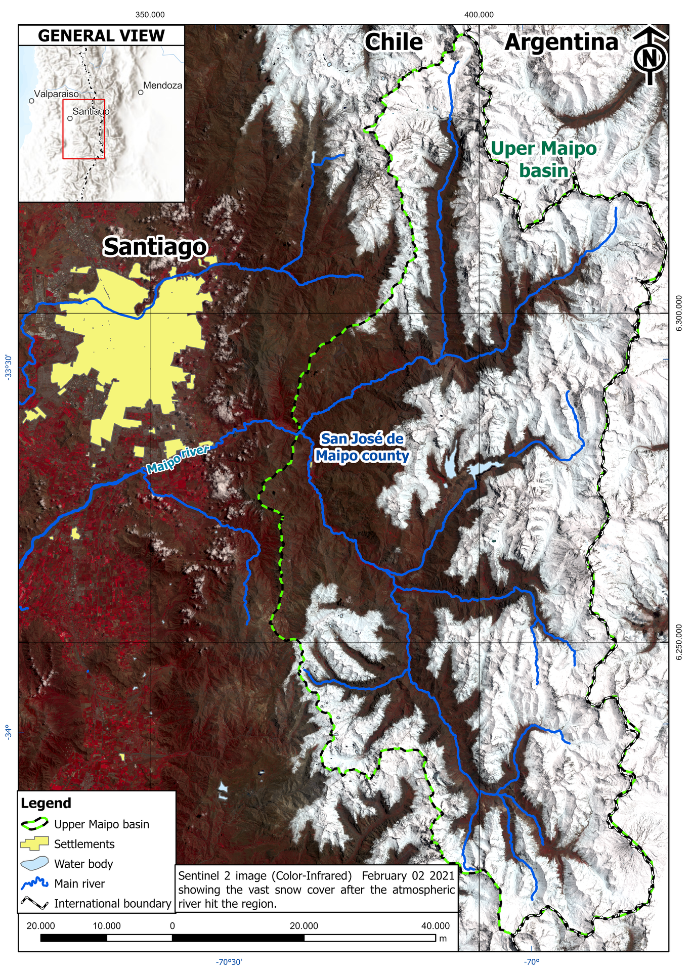
Although scarcely described, intense summer precipitation events in central Chile aren’t an unknown phenomenon, their recurrence is estimated at 40 years. In the last 5 years, 2 heavy rainfall episodes triggered massive debris flows in the San Jose de Maipo county of the Metropolitan Region, located on the upper Maipo river basin, where average precipitation for summer months is only 7 mm. A summary of the current knowledge of the January 28 to 31, 2021 summer rain event is presented. The episode has been attributed to a Zonal Atmospheric River (ZAR), which allowed for a direct transfer of vapour and moisture on a W-E trajectory perpendicular to the Chilean coast. The latter favoured high altitude precipitation, with 0 degree isotherm estimated at 3.700 m a.s.l. On a local range, the snow line was observed between 2,800-3,100 m a.s.l. The event precipitation reached unprecedented values over 60 mm on all stations along the Maipo valley, with a local maximum of 117 mm. 3 pulses have been accounted for rainfall, with a maximum intensity of 11 mm/hour; at the peak of the pulses the Maipo river flow increased 8 times its pre-event flow of 60 m/s. In the following days after the event, 55% of the Upper Maipo basin was covered with snow. Due to sudden higher temperatures a consequent rapid snow melt increased the turbidity of the Maipo river, compromising freshwater supply. Agriculture was also affected, mainly grapes. According to the National Geological and Mining Service, over 120 landslides were triggered during the event, most of them being debris flows with some rock fall affecting the main roads. 700 persons were affected, more than 100 houses resulted with damages, 50 with severe damages and 33 destroyed, mostly at the San Alfonso village. Cost of infrastructure’s lost was estimated over US$4MM. Luckily, there weren’t any fatalities. This feature contrasts with the 25 February 2017 debris flow episode in the same region, with 8 fatal victims. Although local inhabitants have coexisted with this kind of hazards since historical times, uninterrupted urban growth on mountain areas has contributed substantially to an increase in the level of exposure. In this case, the accurate forecasting of the ZAR coupled with an effective risk communication avoided fatalities, nonetheless, it is most likely that this kind of phenomenon will occur again.