Zhe Zhang

and 8 more

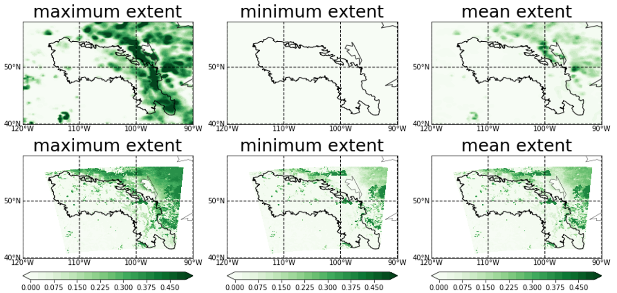
Wetlands are an important land type – they provide vital ecosystem services such as regulating floods, storing carbon, and providing wildlife habitat. The ability to simulate their spatial extent and hydrological processes is important for valuing wetlands’ function. The purpose of this study is to dynamically simulate wetlands’ hydrological processes and their feedback to the regional climate in the Prairie Pothole Region (PPR) of North America, where a large number of wetlands exist. In this study, we incorporated a wetland scheme into the Noah-MP Land Surface Model with two major modifications: (1) modifying the sub-grid saturation fraction for spatial wetland extent; (2) incorporating a dynamic water storage to simulate hydrological processes. This scheme was tested at a fen site in central Saskatchewan, Canada and applied regionally in the PPR with 13-year climate forcing produced by a high-resolution convection-permitting model. The differences between wetland and no-wetland simulations are significant, with increasing latent heat and evapotranspiration while decreasing sensible heat and runoff. Finally, the dynamic wetland scheme was tested using the coupled WRF model, showing an evident cooling effect of 1~3℃ in summer where wetlands are abundant. In particular, the wetland simulation shows reduction in the number of hot days for more than 10 days over the summer of 2006, when a long-lasting heatwave occurred. This research has great implications for land surface/regional climate modeling, as well as wetland conservation, for valuing wetlands in providing a moisture source and mitigating extreme heatwaves, especially under climate change.

Yanping Li

and 7 more

Representing climate-crop interactions is critical to earth system modeling. Despite recent progress in modeling dynamic crop growth and irrigation in land surface models (LSMs), transitioning these models from field to regional scales is still challenging. This study applies the Noah-MP LSM with dynamic crop-growth and irrigation schemes to jointly simulate the crop yield and irrigation amount for corn and soybean in the central U.S. The model performance of crop yield and irrigation amount are evaluated at county-level against the USDA reports and USGS water withdrawal data, respectively. The bulk simulation (with uniform planting/harvesting management and no irrigation) produces significant biases in crop yield estimates for all planting regions, with root-mean-square-errors (RMSEs) being 28.1% and 28.4% for corn and soybean, respectively. Without an irrigation scheme, the crop yields in the irrigated regions are reduced due to water stress with RMSEs of 48.7% and 20.5%. Applying a dynamic irrigation scheme effectively improves crop yields in irrigated regions and reduces RMSEs to 22.3% and 16.8%. In rainfed regions, the model overestimates crop yields. Applying spatially-varied planting and harvesting dates at state-level reduces crop yields and irrigation amount for both crops, especially in northern states. A “nitrogen-stressed” simulation is conducted and found that the improvement of irrigation on crop yields are limited when the crops are under nitrogen stress. Several uncertainties in modeling crop growth are identified, including yield-gap, planting date, rubisco capacity, and discrepancies between available datasets, pointing to future efforts to incorporating spatially-varying crop parameters to better constrain crop growing seasons.