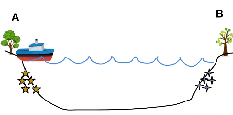
AUTHOREA
Log in Sign Up Browse Preprints
LOG IN SIGN UP

1472 oceanography Preprints

Related keywords
oceanography ice physical oceanography regional climatology microbiology surface waters physical geography ocean-bottom processes meteorology geology hydrology environmental sciences physical climatology geomorphology geography sedimentology polar meteorology marine geology (oceanography) atmospheric sciences shore and near-shore processes topographic geography snow chemical oceanography glaciology climatology (global change) + show more keywords
geophysics numerical modelling paleoclimatology volcanology geochemistry paleontology
FOLLOW
  • Email alerts
  • RSS feed
Please note: These are preprints and have not been peer reviewed. Data may be preliminary.
Prolific nitrite re-oxidation across the Eastern Tropical North Pacific Ocean
Natalya Evans
Juliana Tichota

Natalya Evans

and 3 more

May 02, 2022
Marine Oxygen Deficient Zones serve as hotspots for the loss of fixed nitrogen for the world’s oceans, and fixed nitrogen limits primary productivity in large expanses of the ocean. This fixed nitrogen loss occurs primarily through denitrification, where the stepwise reduction of nitrate to nitrite and ultimately to dinitrogen gas is coupled to organic matter oxidation. Nitrite, the first intermediate in denitrification, can also be re-oxidized back to nitrate in a reaction by chemoautotrophic microbes. Nitrite’s partitioning between reduction and oxidation determines if marine fixed nitrogen is lost or recycled. Nitrite oxidation in anoxic waters has been previously studied through stable and tracer isotope experiments, but the difficulty of these measurements has limited their geographical distribution and therefore requires extrapolation to understand their impact on the nitrogen cycling. Using basin-scale data, we analyze the progression of nutrients within the three water masses that feed the Eastern Tropical North Pacific Oxygen Deficient Zone. Significant deviations from the expected stoichiometry for denitrification demonstrate that 79% of the nitrite produced in the upper region of the Oxygen Deficient Zone is re-oxidized, whereas only 54% of the nitrite produced in the lower region of the Oxygen Deficient Zone is re-oxidized. These large estimates for nitrite re-oxidation reveal significant fixed nitrogen recycling across the Eastern Tropical North Pacific.
REE and Neodymium isotope distribution in the northern South China Sea: particulate d...
Qiong Wu
Zhifei Lliu

Qiong Wu

and 8 more

May 01, 2022
Dissolved rare earth elements (REE) and neodymium isotopic compositions (εNd) were intensively used to evaluate water mass mixing and lithogenic inputs in oceans. The South China Sea (SCS) is the largest marginal sea and a key region for reconstructing past hydrological changes in the West Pacific; however, its REE and εNd distribution are still not well established. This study investigated dissolved REE concentration and εNd distribution at four water stations in the northern and central SCS to better constrain the εNd distribution and REE cycle in the SCS. The results show relatively high concentrations of REE in surface seawater due to the terrigenous inputs. Seasonal variability in the middle REE enrichment is observed, suggesting a controlling role of the lateral mixing of water masses in the REE fractionation. The decreased REE concentrations in bottom water are mainly attributed to the re-suspended particle scavenging. Surface seawater εNd varies from -2.8±0.3 to -6.7±0.3, implying a significant modification due to riverine inputs. The intermediate water is characterized by a slightly negative εNd compared to the North Pacific Intermediate Water (NPIW) suggesting a vertical mixing between the intermediate and deep water within the SCS. εNd of deep water shows a narrow range from -3.4±0.3 to -4.2±0.3 (mean value of ~-3.8), supporting the presence of Pacific Deep Water (PDW) in the deep SCS basins nowadays. εNd of deep water in the SCS behaves conservatively along its pathway from the West Pacific to the SCS even though particle scavenging occurs in bottom water.
Mean Sea Surface Model over the Sea of Japan and its Adjacent Ocean Determined from M...
yupeng niu
Jinyun Guo

yupeng niu

and 4 more

August 01, 2020
Key Points:  A new mean sea surface model with a grid of over the Sea of Japan and its adjacent ocean (named SJAO2020) is established  The new altimetry data of HaiYang-2A, Jason-3 and Sentinel-3A have been used in establishing the SJAO2020 model  Tide gauge stations and joint GNSS are used to improve the offshore accuracy of the SJAO2020 model. Abstract The mean sea surface (MSS) model is an important reference for the study of sea level change and charting data, and the coastal accuracy of the model has always been the focus of marine geophysics and oceanography. A new MSS model with a grid of over the Sea of Japan and its adjacent ocean (named SJAO2020) (25°N~50°N, 125°E~150°E), is established from a combination of 26 years of satellite altimeter data from a total of 12 different satellites and records of 24 tide gauge stations and joint GNSS data covering the period 1993-2018 by a 19-year moving average method. Different from the latest international MSS models CLS15 and DTU18, the data of the latest altimetry satellites HY-2A, Janson-3 and Sentinel-3A are also introduced, and tide gauge records as well as the joint GNSS data are used to correct the SSH within 10 km from the coastline by using the Gaussian inverse distance weighting method in the SJAO2020 model. By comparing with tide gauge records, satellite altimeter data and other models (DTU18, DTU15, CLS11 and WHU13), it can be demonstrated that the SJAO2020 model produces the smallest errors, and its offshore accuracy is relatively reliable.
Near-Continuous Monitoring of a Coastal Salt Marsh Margin: Implications to Predicting...
Jack A. Cadigan
Navid Jafari

Jack A. Cadigan

and 6 more

July 31, 2020
Mechanisms that control marsh edge erosion include wind-generated waves, vegetation, mudflats, anthropogenic factors, and geotechnical properties of sediments. However, existing models for predicting marsh edge evolution focus primarily on edge retreat rates as a function of wave energy while accounting for other controlling factors as empirical constants. This simplification rises from a lack of high frequency monitoring of marsh evolutions. In particular, marsh erosion is time-scale dependent and conducting field observations on short time and spatial scales could elucidate the progression of erosion, which may improve marsh erosion predictive models. This study developed and validated a near continuous camera monitoring system to document marsh edge erosion at a high frequency in Terrebonne Bay, Louisiana. Erosion pins were monitored with the cameras and daily erosion rates were estimated. This was supplemented with daily wave power to explore the relationships between daily erosion and wave power. The largest magnitude erosion events are driven by a buildup in wave energy over a seven-day time period coupled with a strong one-day wave event, indicating a gradual reduction in marsh edge resistance with continued wave attack. Long-term erosion monitoring methods, including monthly field visits, smooths over the large magnitude short-term erosion events. For example, satellite and aerial imagery provide a long period of record, but they seem to underestimate the average annual erosion rate in the region, the effect of which may become exasperated over the varying temporal scales considered in the planning efforts of projects meant to protect the Louisiana coastline.
Watermass co-ordinates isolate the historical climate change signal
Taimoor Sohail
Ryan Holmes

Taimoor Sohail

and 2 more

May 17, 2022
Persistent warming and water cycle change due to anthropogenic climate change modifies the temperature and salinity distribution of the ocean over time. This ‘forced’ signal of temperature and salinity change is often masked by the background internal variability of the climate system. Analysing temperature and salinity change in watermass-based coordinate systems has been proposed as an alternative to traditional Eulerian (e.g., fixed-depth, zonally-averaged) co-ordinate systems. The impact of internal variability is thought to be reduced in watermass co-ordinates, enabling a cleaner separation of the forced signal from background variability - or a higher ‘signal-to-noise’ ratio. Building on previous analyses comparing Eulerian and water-mass-based one-dimensional coordinates, here we recast two-dimensional co-ordinate systems - temperature-salinity (T-S), latitude-longitude and latitude-depth - onto a directly comparable equal-volume framework. We compare the internal variability, or ‘noise’ in temperature and salinity between these remapped two-dimensional co-ordinate systems in a 500 year pre-industrial control run from a CMIP6 climate model. We find that median internal variability is reduced in both ocean heat and salt content in T-S space compared to Eulerian coordinates, and that a large proportion of variability in T-S space can be attributed to processes which operate over a timescale greater than 10 years. We show that, as a consequence of the reduced projection of internal variability into T-S space, the signal-to-noise ratio in watermass co-ordinates is at least two times greater than in Eulerian co-ordinate systems, implying that the climate change signal can be more robustly identified.
Ocean biogeochemical signatures of the North Pacific Blob
Samuel Mogen
Nicole Suzanne Lovenduski

Samuel Mogen

and 11 more

November 11, 2021
The Blob was a marine heat wave in the Northeast Pacific from 2013 to 2016. While the upper ocean temperature in the Blob has been well described, the impacts on marine biogeochemistry have not been fully studied. Here, we characterize and develop understanding of Eastern North Pacific upper ocean biogeochemical properties during the Winter of 2013-14 using in situ observations, an observation-based product, and reconstructions from a collection of ocean models. We find that the Blob is associated with significant upper ocean biogeochemical anomalies: a 5% increase in aragonite saturation state (temporary reprieve of ocean acidification) and a 3% decrease in oxygen concentration (enhanced deoxygenation). Anomalous advection and mixing drives the aragonite saturation anomaly, while anomalous heating and air-sea gas exchange drive the oxygen anomaly. Marine heatwaves do not necessarily serve as an analogue for future change as they may enhance or mitigate long-term trends.
Deep Ash Plumes Signal Ongoing or Recent Submarine Volcanic Eruptions, and Demonstrat...
Sharon Walker
Edward Baker

Sharon Walker

and 10 more

January 07, 2020
The considerable challenges of accessing unpredictable events at remote seafloor locations make submarine eruptions difficult to study in real time. The serendipitous discovery of two persistently active sites (NW Rota-1 in the Mariana arc, at ~550 m, and West Mata in the NE Lau basin at ~1200 m) resulted in multi-year, multi-parameter studies that included water column plume surveys and direct (ROV) observations. Intense magmatic-hydrothermal plumes rose buoyantly above both sites, while deep particle plume layers, dominated by fine ash and devoid of hydrothermal tracers, were found dispersing laterally on isopycnal surfaces at variable depths below the eruptive vents and above the seafloor. The presence or absence of deep ash plumes was directly correlated with explosive activity or quiescence, respectively. An estimated 0.4-14.6 x 10⁵ m3/yr of fine ash entered the water column surrounding these volcanoes and remained suspended at distances exceeding 10’s of km. We show that deep ash plume layers in the water column are a common feature of explosive submarine eruptions at other sites as well, and that they demonstrate a syn-eruptive mode of transport for fine ash that will result in deposition as “hidden” cryptotephra or fallout deposits in marine sediments at distances greater than previously predicted. Cruise FK171110 extended the time series of observations at West Mata, and resulted in discovery of new lava flows emplaced after September 2012, with one constrained between March 2016 and November 2017. ROV dives confirmed that West Mata was quiescent during this expedition, but widespread deep ash plumes were present. Turbidity in the deep ash plumes decreased by 80% over a 25-day period, with an average loss of 3% (0.15-0.6 g/m2) per day, suggesting the eruption that formed the 2016-2017 eruptive deposits had occurred within 8-121 days prior to the FK171110 expedition. Future studies of submarine volcanic processes will depend on improved exploration and event detection capabilities. In addition to recognizing the characteristic hydrothermal event plumes rising into the water column above actively erupting sites, widespread ash plumes dispersing at depths deeper than eruptive vents can also be diagnostic of ongoing, or very recent, eruptions. We infer the eruptive status at other sites based on these criteria.
Acoustic and In-situ Observations of Hydrothermal Discharge at ASHES Vent Field: an O...
Guangyu Xu
Karen Bemis

Guangyu Xu

and 3 more

January 07, 2020
The Cabled Observatory Vent Imaging Sonar (COVIS) was initially installed on the Ocean Observatories Initiative’s Cabled Array (OOI-CA) observatory at ASHES hydrothermal vent field on Axial Seamount in July 2018. COVIS recorded the acoustic backscatter from the water-column plumes formed above hydrothermal sources and the seafloor within the sonar’s field-of-view until Oct 2018, when an instrument malfunction suspended regular data-collection procedures. In July 2019, COVIS was redeployed after repairs and has since been collecting data at full capacity. Here, we present a comprehensive analysis of the acoustic backscatter data recorded by COVIS along with the in-situ temperature measurements in 2018 and 2019. The results demonstrate significant influences of ocean tides and bottom currents on diffuse hydrothermal discharge within ASHES. In addition, comparison with local seismicity shows a positive correlation between diffuse hydrothermal venting and the seismic activity in the vicinity of the vent field, which provides evidence for an intimate connection between hydrothermal activity and geological processes during the dynamic period leading up to the next eruption of Axial Seamount. Overall, our results showcase the capabilities of underwater acoustic techniques as remote-sensing tools for long-term, quantitative monitoring of seafloor hydrothermal discharge.
Machine Learning Techniques for Regional Scale Estimation of High- Resolution Cloud-F...
RAAJ Ramsankaran
Swathy Sunder

RAAJ Ramsankaran

and 2 more

April 08, 2020
High-resolution sea surface temperature (SST) estimates are dependent on satellite-based infrared radiometers, which are proven to be highly accurate in the past decades. However, the presence of clouds is a big stumbling block when physical approaches are used to derive SST. This problem is more prominent across tropical regions such as Arabian Sea(AS) and Bay of Bengal(BoB), restricting the availability of high-resolution SST data for ocean applications. The previous studies for developing daily high-resolution cloud-free SST products mainly focus on fusion of multiple satellites and in-situ data products that are computationally expensive and often time consuming. At the same time, it was observed that the capabilities of data-driven approaches are not yet fully explored in the estimation of cloud-free high-resolution SST data. Hence, in this study an attempt has been made for the first time to estimate daily cloud free SST from a single sensor (MODIS Aqua) dataset using advanced machine learning techniques. Here, three distinct machine learning techniques such as Artificial Neural Networks (ANN), Support Vector Regression (SVR) and Random Forest (RF)-based algorithms were developed and evaluated over two different study areas within the AS and BoB using 10 years of MODIS data and in-situ reference data. Among the developed algorithms, the SVR-based algorithm performs consistently better. In AS region, while testing, the SVR-based SST estimates was able to achieve an adjusted coefficient of determination (R_adj^2) of 0.82 and root mean square error (RMSE) of 0.71°C with respect to the in situ data. Similarly, in BoB too, the SVR algorithm outperforms the other algorithms with R_adj^2 of 0.78 with RMSE of 0.88ºC. Further, a spatio-temporal and visual analysis of the results as well as an inter-comparision with NOAA AVHRR daily optimally interpolated global SST (a standard SST product available in practice) the suggest that the proposed SVR-based algorithm has huge potential to produce operational high-resolution cloud-free SST estimates, even if there is cloud cover in the image.
Organic Matter Composition of Biomineral Flocs and its Influence on Suspended Particu...
Michael Fettweis
Markus Schartau

Michael Fettweis

and 6 more

April 07, 2021
The seasonal variation in concentration of transparent exopolymer particles (TEP), particulate organic carbon (POC) and nitrogen (PON) were investigated together with floc size and the concentration of suspended particulate matter (SPM) along the cross-shore gradient, from the high turbid nearshore towards the low-turbid offshore waters in the southern Bight of the North Sea. The analyses of TEP, POC and PON result in a set of parameters that incorporate labile and refractory organic matter (OM) fractions. Our data demonstrate that biophysical flocculation cannot be explained by these heterogeneous parameters, but requires a distinction between a more reactive labile (“fresh”) and a less reactive refractory (“mineral-associated”) fraction. Based on all data we separated the labile and mineral-associated POC, PON and TEP using a semi-empirical model approach. The model’s estimates of fresh and mineral-associated OM show that great parts of the POC, PON and TEP are associated with suspended minerals, which are present in the water column throughout the year, whereas the occurrence of fresh TEP, POC and PON is restricted to spring and summer months. In spite of a constantly high abundance of total TEP throughout the entire year, it is its fresh fraction that promotes the formation of larger and faster sinking biomineral flocs, thereby contributing to reduce the SPM concentration in the water column over spring and summer. Our results show that the different components of the SPM, such as minerals, extracellular OM and living organisms, form an integrated dynamic system with direct interactions and feedback controls.
Tephra deposition enhances organic carbon burial in the Bering Sea
Jack Longman
Thomas Gernon

Jack Longman

and 3 more

April 06, 2021
Preservation of organic carbon (OC) in marine sediments exerts a major control on the cycling of carbon in the Earth system. In marine sediment, OC preservation may be enhanced by diagenetic reactions in locations where deposition of tephra occurs. While the mechanisms by which this process occurs are well understood, site-specific studies are limited. Here, we report on a study of sediments from the Bering Sea (IODP Site U1339D) to investigate the effects of marine tephra deposition on carbon cycling during the Pleistocene and Holocene. Our results strongly suggest that tephra layers are loci of OC burial with distinct d13C values, and that this process is primarily linked to complexation of OC with reactive metals (accounting for ~80% of all OC within tephra layers). In addition, distribution of reactive metals into non-volcanic sediments above and below the tephra layers enhances OC preservation in these sediments, with ~33% of OC bound to reactive phases. Importantly, OC-Fe coupling is evident in sediments >700,000 years old. Thus, these interactions may help explain the preservation of labile OC in older marine sediments.
The global overturning circulation and the importance of non-equilibrium effects in E...
Tatsu Monkman
Malte Friedrich Jansen

Tatsu Monkman

and 1 more

September 22, 2021
We quantify the volume transport and watermass transformation rates of the global ocean circulation using data from the Estimating the Circulation and Climate of the Ocean version 4 release 3 (ECCOv4r3) reanalysis product. Our results support large rates of intercell exchange between the mid-depth and abyssal cells, in agreement with modern theory and observations. However, the present-day circulation in ECCO cannot be interpreted as a near-equilibrium solution. Instead, a dominant portion of the apparent diapycnal transport of watermasses within the deep ocean is associated with isopycnal volume change, rather than diabatic processes, reflecting trends in the deep ocean density structure. Our results imply two possibilities: either such trends in ECCOv4r3 are unrealistic, implying that ECCO’s representation of the overturning circulation and watermass transformations are inconsistent, or the trends in ECCOv4r3 are realistic and equilibrium theories of the overturning circulation cannot be applied to the present-day ocean.
The role of river discharge and geometric structure on diurnal tidal dynamics, Alabam...
Steven Louis Dykstra
briandz

Steven Louis Dykstra

and 2 more

September 22, 2021
As tides propagate inland, they become distorted by channel geometry and river discharge. Tidal dynamics in fluvial-marine transitions are commonly observed in high-energy tidal environments with relatively steady river conditions, leaving the effects of variable river discharge on tides and longitudinal changes poorly understood. To study the effects of variable river discharge on tide-river interactions, we studied a low-energy tidal environment where river discharge ranges several orders of magnitude, the diurnal microtidal Tombigbee River-Mobile Bay fluvial-marine transition, using water level and velocity observations from 21 stations. Results showed that tidal attenuation was reduced by the width convergence in seaward reaches and height convergence of the landward backwater reaches, with the channel convergence change location ~40-50km inland of the bayhead and seaward of the largest bifurcation (~rkm 90-100). River events amplified tides in seaward regions and attenuated tides in landward regions. This created a region of river-induced peak amplitude seaward of the flood limit (i.e., bidirectional-unidirectional current transition) and passed more tidal energy inland. Tidal currents were attenuated and lagged more with river discharge than water levels, making the phase lag dynamic. The river impacts on the tides were delineated longitudinally and shifted seaward as river discharge increased, ranging up to ~180 km. Results indicated the location and longitudinal shifts of river impacts on tides in alluvial systems can be estimated analytically using the ratio of river discharge to tidal discharge and the geometry convergence. Our simple analytical theory provides a pathway for understanding the tide-river-geomorphic equilibrium along increasingly dynamic coasts.
Identifying efficient ensemble perturbations for initializing subseasonal-to-seasonal...
Jonathan Demaeyer
Stephen Gregory Penny

Jonathan Demaeyer

and 2 more

September 22, 2021
The prediction of the weather at subseasonal-to-seasonal (S2S) timescales is dependent on both initial and boundary conditions. An open question is how to best initialize a relatively small-sized ensemble of numerical model integrations to produce reliable forecasts at these timescales. Reliability in this case means that the statistical properties of the ensemble forecast are consistent with the actual uncertainties about the future state of the geophysical system under investigation. In the present work, a method is introduced to construct initial conditions that produce reliable ensemble forecasts by projecting onto the eigenfunctions of the Koopman or the Perron-Frobenius operators, which describe the time-evolution of observables and probability distributions of the system dynamics, respectively. These eigenfunctions can be approximated from data by using the Dynamic Mode Decomposition (DMD) algorithm. The effectiveness of this approach is illustrated in the framework of a low-order ocean-atmosphere model exhibiting multiple characteristic timescales, and is compared to other ensemble initialization methods based on the Empirical Orthogonal Functions (EOFs) of the model trajectory and on the backward and covariant Lyapunov vectors of the model dynamics. Projecting initial conditions onto a subset of the Koopman or Perron-Frobenius eigenfunctions that are characterized by time scales with fast-decaying oscillations is found to produce highly reliable forecasts at all lead times investigated, ranging from one week to two months. Reliable forecasts are also obtained with the adjoint covariant Lyapunov vectors, which are the eigenfunctions of the Koopman operator in the tangent space. The advantages of these different methods are discussed.
Coastal freshening enhances eddy-driven heat transfer toward the Antarctic margins
Yidongfang Si
Andrew Stewart

Yidongfang Si

and 2 more

January 31, 2022
The Antarctic Slope Front (ASF) is a strong gradient in water mass properties close to the Antarctic margins. Heat transport across the ASF is important to Earth’s climate, as it influences melting of ice shelves, the formation of bottom water, and thus the global meridional overturning circulation. Previous studies based on relatively low-resolution models have reported contradictory findings regarding the impact of additional meltwater on onshore heat transport onto the Antarctic continental shelf: it remains unclear whether meltwater enhances shoreward heat transport, leading to a positive feedback, or further isolates the continental shelf from the open ocean. In this study, heat transport across the ASF is investigated using high-resolution, process-oriented simulations. It is found that shoreward heat transport is primarily controlled by the salinity gradient of the shelf waters: both freshening and salinification of the shelf waters relative to the offshore waters lead to increased heat flux onto the continental shelf. For salty shelves, the overturning consists of a dense water outflow that drives a shoreward heat flux near the seafloor; for fresh shelves, there is a shallow, eddy-driven overturning circulation that is associated with an export of fresh surface waters and a near-surface shoreward heat flux. The eddy-driven overturning associated with coastal freshening may lead to a positive feedback in a warming climate: large volumes of meltwater increase shoreward heat transport, causing further melt of ice shelves.
The world ocean wave fields discerned from ERA-Interim spectra
Jesus Portilla Yandun

Jesus Portilla Yandun

January 31, 2022
Ocean waves at any particular location are the result of the superposition of locally generated waves by wind, plus swells advected from somewhere else. Swells in particular can travel very long distances with marginal energy loss such that their signal, albeit reduced by dispersion, can be detected all across the oceans. Although our current approach for wave modeling and description has the wave spectrum as standard variable, most wave characterization methods are based on simplified integral parameters (e.g., Hs, Tm). These are indicative of the overall magnitude, but loose all the information stored in the spectral structure. Therefore, total wave fields derived from integral parameters are smooth and continuous while in reality wave fields have well defined spatial domains, they overlap one another, and they vary significantly along the seasons in response to the ever changing meteorological forcing. Using spectral partitioning techniques and the global spectral wave climate atlas GLOSWAC, the main wave fields active in the different ocean basins can be elucidated and separated from the integrated one. As the memory of the sea surface (waves) is longer than that of the atmosphere, these individual wave fields constitute a valuable new source of environmental information, and its characterization opens the way to more advanced wave analysis methods.
Formation of the Galapagos Microplate and its Effect on Rifting at the Galapagos Trip...
Deborah Smith
Hans Schouten

Deborah Smith

and 6 more

January 15, 2020
The Galapagos microplate formed at 1.4 Ma, initiating Nazca–Galapagos magmatic spreading along its southern and eastern borders. We examine in detail the formation and evolution of the microplate and its effect on the major rift boundaries of the Galapagos triple junction region. We show that the microplate originated by breaks along three pre-existing zones of structural weakness in the Nazca lithosphere: 1) to the south, an active ‘secondary rift’ located ~50 km south of the Pacific-Cocos-Nazca triple junction; 2) to the east, faults associated with the off-axis East Pacific Rise (EPR) abyssal hill fabric, and 3) to the north, the deep normal faults of the southern scarp of the Galapagos gore (the faulted boundary between the Pacific-Nazca and the Cocos-Nazca regimes). The breaks were likely forced by the appearance of a significant magmatic anomaly that crossed the EPR, flooded the ‘secondary rift’ in the south with lavas and shortly thereafter, created two large seamounts (~1500 m and ~1000 m in relief) on the southern boundary. This magmatic anomaly may also be associated with the unusually high elevation of Dietz Volcanic Ridge west of the seamounts, which resembles the rift zones of Axial Seamount on the Juan de Fuca Ridge in height, width and length. Dietz Volcanic Ridge is the present southern boundary of the Galapagos microplate and opens at ~33 mm/yr. It is ~900 m in relief and 7.5-8 km wide at its shallowest section. Rock samples dredged from the shallow section of the ridge in 2018 on the R/V Sally Ride support the idea of a magmatic anomaly in this area. The rocks are transitional MORB that are more enriched than any Cocos-Nazca lavas or the adjacent EPR that were sampled (see Wernette et al. 2019 abstract). The residual mantle Bouguer anomaly indicates thicker crust associated with the two seamounts and the eastern section of Dietz Volcanic Ridge (see Zheng et al. 2019 abstract). We also examine the response of the Cocos-Nazca rift and the EPR to the arrival of the magmatic anomaly and microplate formation. The Galapagos triple junction region is complex, but this complexity provides an opportunity to obtain a better understanding of how plates deform internally near their boundaries, and the relationship between this deformation and upwelling mantle material.
Greenland Ice Sheet Contribution to 21st Century Sea Level Rise as Simulated by the C...
Laura Muntjewerf
Michele Petrini

Laura Muntjewerf

and 10 more

January 06, 2020
The Greenland Ice Sheet (GrIS) mass balance is examined with an Earth system/ice sheet model that interactively couples the GrIS to the land and atmosphere. The simulation runs from 1850 to 2100, with historical and SSP5-8.5 forcing. By mid-21st century, the cumulative contribution to global mean sea level rise (SLR) is 23 mm. Over the second half of the 21st century, the surface mass balance becomes negative in all drainage basins, and an additional 86 mm of SLR is contributed. The annual mean GrIS mass loss in the last two decades is 2.7 mm sea level equivalent (SLE) yr-1. Strong decrease in SMB (3.1 mm SLE yr-1) is counteracted by a reduction in ice discharge from thinning and retreat of outlet glaciers. The southern GrIS drainage basins contribute 73% of the mass loss by mid-century. This decreases to 55% by 2100, as surface runoff in the northern basins strongly increases.
The Neogene Indian Ocean Record of Asian monsoon Driven Ocean Currents and Winds from...
Christian Betzler
Gregor Eberli

Christian Betzler

and 4 more

January 06, 2020
The Maldives archipelago acts for over 25 myrs as a giant natural sediment trap in the eastern Arabian Sea. Drifts and periplatform deposits bear the record of environmental changes such as sea-level fluctuations but also of monsoon-driven changes of the surface and intermediate water mass current regime, and of wind-driven dust influx. Carbonate drifts in the Inner Sea indicate the establishment of a strong wind-driven current regime in the Maldives at 12.9 – 13 Ma. Ten unconformities, dissecting the Miocene to Recent drift sequences, attest to changes in current strength or direction. A major shift in the drift packages is dated at 3.8 Ma that coincides with the end of stepwise platform drowning and a reduction of the OMZ in the Inner Sea. The lithogenic fraction of the Maldives carbonate drifts provides a unique record of atmospheric dust transport during the past 4 myrs as grain size provides proxies for dust flux as well as wind transport capacity. Entrainment and long-range transport of dust in the medium to coarse silt size range is linked to the strength of the Arabian Shamal winds and the occurrence of convective storms which prolong dust transport. Dust flux and the size of dust particles increased between 4.0 and 3.3 Ma, corresponding to the closure of the Indonesian seaway and the intensification of the South Asian Monsoon. Between 1.6 Ma and the Recent, dust flux again increased and shows higher variability, especially during the last 500 kyr. Transport capacity increased between 1.2 and 0.5 Ma but slightly decreased since then. Dust transport varies on orbital timescales, with eccentricity control being the most prominent (400 kyr throughout the record, 100 kyr between 2.0 and 1.3 Ma, and since 1.0 Ma). Higher frequency cycles (obliquity and precession) are most pronounced in wind transport capacity. The published and ongoing studies of IODP Expedition 359 cores show that deposits surrounding carbonate platforms, i.e. carbonate drifts, bear a previously underestimated potential to add substantial knowledge for the understanding of the monsoon evolution on million-year, but also on shorter time scales. Potential targets for further research and drilling are for example the Laccadives, the Mascarene Plateau or the South China Sea platforms.
A near-global climatology of oceanic coherent eddies
Josué Martínez-Moreno
Andy Hogg

Josué Martínez-Moreno

and 2 more

April 22, 2021
Ocean eddies influence regional and global climate through mixing and transport of heat and properties. One of the most recognizable and ubiquitous feature of oceanic eddies are coherent vortices with spatial scales of tens to hundreds of kilometers, frequently referred as “mesoscale eddies”. Coherent mesoscale eddies are known to transport properties across the ocean and to locally affect near-surface wind, cloud properties, and rainfall patterns. Although coherent eddies are ubiquitous, their climatology, seasonality, and long-term temporal evolution remains poorly understood. Here, we examine the kinetic energy contained by coherent eddies and present the seasonal, interannual and long-term variability using satellite observations between 1993 to 2019. A total of $\sim$37 million coherent eddies are detected in this analysis. Around 50% of the kinetic energy contained by ocean eddies corresponds to coherent eddies. Additionally, a strong seasonal cycle is observed, with a 3-6 months lag between the wind forcing and the response of the coherent eddy field. The seasonality of the number of coherent eddies and their amplitude reveals that the number of coherent eddies responds faster to the forcing ($\sim$3 months), than the coherent eddy amplitude (which lags by $\sim$6 months). This seasonal cycle is spatially variable, so we also analyze their climatology in key oceanic regions. Our analysis highlights the relative importance of the coherent eddy field in the ocean kinetic energy budget, implies a strong response of the eddy number and eddy amplitude to forcing at different time-scales, and showcases the seasonality, and multidecadal trends of coherent eddy properties.
Subsurface Eddy Facilitates Retention of Diel Vertical Migrators in a Biological Hots...
Katherine L Hudson
Matthew John Oliver

Katherine L Hudson

and 8 more

April 21, 2021
Diel vertical migration (DVM) is a common behavior in zooplankton populations world-wide. Every day, zooplankton leave the productive surface ocean and migrate to deep, dark waters to avoid visual predators and return to the surface at night to feed. This behavior may also help retain migrating zooplankton in biological hotspots. Compared to fast and variable surface currents, deep ocean currents are sluggish, and can be more consistent. The time spent in the subsurface layer are driven by day length and the depth of surface mixed layer. A subsurface, recirculating eddy has recently been described in Palmer Deep Canyon, a submarine canyon adjacent to a biological hotspot. Previous circulation model simulations have shown that residence times of particles increase with depth within this feature. We hypothesize that DVM into the subsurface eddy increases local retention of migrating zooplankton in this biological hotspot and that shallower mixed layers and longer day length would increase the time in the subsurface layer. We demonstrate that vertically migrating particles have residence times on the order of 30 days, which is significantly greater than residence times of near-surface, non-migrating particles. The interaction of DVM with this subsurface feature may be important to the establishment of the biological hotspot within Palmer Deep Canyon by retaining critical food resources in the region. Similar interactions between DVM behavior and subsurface circulation features, modulated by mixed layer depth and day length, may also increase residence times of local zooplankton populations elsewhere.
The Dependence of Tropical Modes of Variability on Zonal Asymmetry
Xiaoning Wu
Kevin A. Reed

Xiaoning Wu

and 5 more

April 22, 2021
Tropical modes of variability, including the Madden‐Julian Oscillation (MJO) and the El Niño‐Southern Oscillation (ENSO), are challenging to represent in climate models. Previous studies suggest their fundamental dependence on zonal asymmetry, but such dependence is rarely addressed with fully coupled ocean dynamics. This study fills the gap by using fully coupled, idealized Community Earth System Model (CESM) and comparing two nominally ocean-covered configurations with and without a meridional boundary. For the MJO-like intraseasonal mode, its separation from equatorial Kelvin waves and the eastward propagation of its convective and dynamic signals depend on the zonal gradient of the mean state. For the ENSO-like interannual mode, in the absence of the ocean’s meridional boundary, a circum-equatorial dominant mode emerges with distinct ocean dynamics. The interpretation of the dependence of these modes on zonal asymmetry is relevant to their representation in realistic climate models.
A method for applying lateral surface eddy diffusion in ocean models with a general v...
Gustavo Marques
Andrew E. Shao

Gustavo M. Marques

and 4 more

April 21, 2021
The mixing of tracers by mesoscale eddies, parameterized in many ocean general circulation models (OGCMs) as a diffusive process, contributes significantly to the distribution of tracers in the ocean. In the ocean interior, such processes occur mostly along the direction parallel to the local neutral density surface. However, near boundaries, small-scale turbulence breaks this constraint and the mesoscale transport occurs mostly along a plane parallel to the boundary (i.e., laterally near the surface of the ocean). Although this process is easily represented in OGCMs with geopotential vertical coordinates, the representation is more challenging in OGCMs that use a general vertical coordinate, where surfaces can be tilted with respect to the horizontal. We propose a method for representing the diffusive lateral mesoscale fluxes within the surface boundary layer of general vertical coordinate OGCMs. The method relies on regridding/remapping techniques to represent tracers in a geopotential grid. Lateral fluxes are calculated in this grid and then remapped back to the native grid, where fluxes are applied. The algorithm is implemented in an ocean model and tested in idealized and realistic settings. Lateral diffusion reduces the vertical stratification of the upper ocean, which results in an overall deepening of the surface boundary layer depth. Although the impact on certain global metrics is not significant, enabling lateral diffusion leads to a small but meaningful reduction in the near-surface global bias of potential temperature and salinity.
Comparison of Extreme Coastal Flooding Events Between Tropical and Mid-Latitude Weath...
John Callahan
Daniel Leathers

John Callahan

and 2 more

April 21, 2021
Coastal flooding is one of the most costly and deadly natural hazards facing the US Mid-Atlantic region today. Impacts in this heavily populated and economically significant region are caused by a combination of the location’s exposure and natural forcing from storms and sea-level rise. Tropical cyclones (TCs) and mid-latitude (ML) weather systems each have caused extreme coastal flooding in the region. Skew surge was computed over each tidal cycle for the past 40 years (1980 – 2019) at several tide gauges in the Delaware and Chesapeake Bays to compare the meteorological component of surge for each weather type. Although TCs cause higher mean surges, ML weather systems can produce surges just as severe and occur much more frequently, peaking in the cold season (Nov – Mar). Of the top 10 largest surge events, TCs account for 30-45% in the Delaware and upper Chesapeake Bays and 40–45% in the lower Chesapeake Bay. This percentage drops to 10-15% for larger numbers of events in all regions. Mean sea-level pressure and 500 hPa geopotential height (GPH) fields of the top 10 surge events from ML weather systems show a low-pressure center west-southwest of Delmarva and a semi-stationary high-pressure center to the northeast prior to maximum surge, producing strong easterly winds. Low-pressure centers intensify under upper-level divergence as they travel eastward, and the high-pressure centers are near the GPH ridges. During lower bay events, the low-pressure centers develop further south, intensifying over warmer coastal waters, with a south-shifted GPH pattern compared to upper bay events.
← Previous 1 2 … 44 45 46 47 48 49 50 51 52 … 61 62 Next →
Back to search
Authorea
  • Home
  • About
  • Product
  • Preprints
  • Pricing
  • Blog
  • Twitter
  • Help
  • Terms of Use
  • Privacy Policy